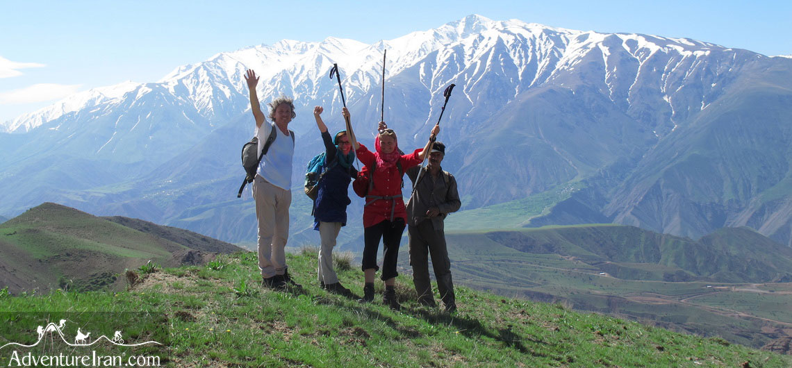
10 Best Off the Beaten Path Hiking Trails in Iran
Iran’s geographical location has made it one of the most exceptional countries in the world for hiking. There are two seas in the north and south of the country, as well as the two long mountain ranges of Alborz and Zagros. Moreover, a lot of sub-ranges and mountain chains, high-altitude peaks in each corner of the country, the famous Hyrcanian forests (UNESCO), and two vast deserts of Dasht-e Kavir and Lut (UNESCO) plus numerous springs and lakes have made Iran unique. Iran, with so much to see as well as numerous Off the Beaten hiking trails, is perfect for all types of hikers who wish to experience an unusual and exciting journey.
The varieties of terrain and climate have created amazing opportunities for freak (atypical) hikers to hike in different regions all year round. Having excellent information about the Off the Beaten hiking trails in Iran and knowing the right regions in the right month is one of the main steps to have a memorable trekking holiday. Another advantage of Iran is enjoying a varied climate and ecosystem simultaneously in its different regions. To give you a better idea, we will explain a few of Adventure Iran’s tours during spring.
While we perform hiking tours in the forests, south of the Caspian Sea, we also have other hiking tours in the central Alborz mountains, north of Tehran. At the same time, we have another hiking tour in the Dasht-e Kavir desert located in central Iran. We have had a lot of experience performing these tours. As there is still snow on the high-altitude mountains in the central parts of the country, you will see a lot of flowers and trees in bloom while people in the south of Iran, in the Persian Gulf region, experience high temperatures like summer in Tehran.
This is how we live in Iran, experiencing diverse climate and weather conditions, throughout the various regions. Here we would like to share Iran’s 10 best Off the Beaten hiking trails that you may want to choose from for your next adventure holiday in Iran.
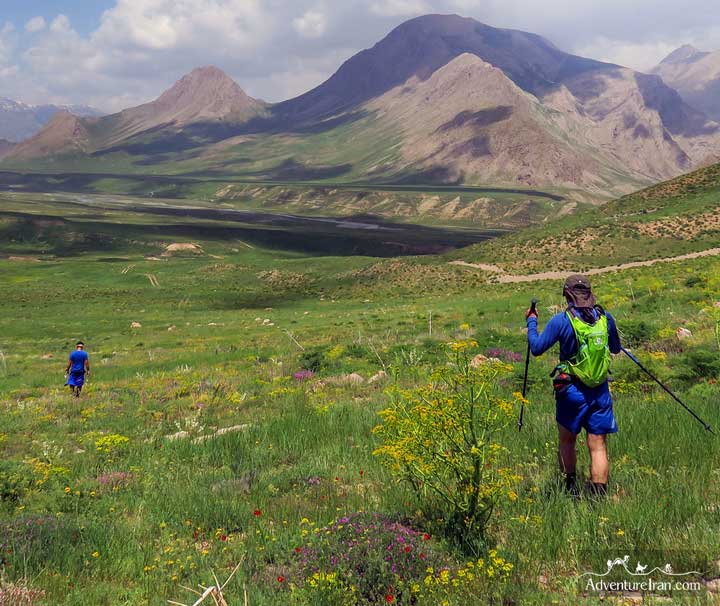
1. Dena Mountain Chain
Dena is one of the most important sub-ranges of the Zagros Mountains in Iran. It is around 90 km in length with many beautiful peaks above 4000 m. At the base of the mountain, there is the National Park of Dena, a UNESCO Biosphere Reserve site. MT Ghash Mastan or Bijan 3 (4,450m) in Dena is the highest peak in this range. It is also the highest mountain in the whole of the Zagros mountains. You can have different hiking tours in Dena ranges, from a 2-day short hike up to a couple of weeks. There are many different trails and peaks on the ridge line of this mountain chain. Hiking in Dena ridge is one of the most amazing treks in the high-altitude mountains of Iran. The huge oak forest at the foothills of the mountains has created a spectacular landscape that is really pleasant for hiking.
For those who would like to have a couple of days hiking, with a moderate level of difficulty, hiking in the foothills of the Dena mountain is one of the best choices; it offers a lot of enjoyment in this protected area. There are a number of villages on both sides of the range, where you can see locals farming in this park.
For those of you who would like to ascend one or two peaks above 4000 m, there are two different trails that go up to one of the main peaks of the Dena chain. There are two starting points for these two trails. One is in the southwest of the chain and the other is in the northeast of the range. Shiraz and Esfahan are two cities where you can have excellent access to these two trails. For hiking or ascending the peak, there are two shelters on both sides where you can spend the night. There is no spring water available, so without having access to water on either side of the mountain, you must bring with you all the water you will need for your hiking tour.
For those who would like to have a long trek and experience a special hiking route, you can hike on the ridge of the chain and ascend some of the high peaks; then experience two overnight stays in a tent at a high altitude.
The best season for hiking in Dena is spring, summer, and early autumn. If you are thinking of ascending one of the peaks, summer is the best time to climb one of the high summits in this range. For the two above routes, the southwest and northeast trails, you don’t need to be a professional climber or have special equipment to reach the famous peaks. As the Dena region is inside the national park, it is necessary to have a permit to enter the park, by applying for it in advance with your Iranian tour operator. This is the link to MT Dena photos that we took from our various trips with our travelers:
no images were found
2. Azad Kuh Mountain (4,400 m)
Mt Azad Kuh is one of the most beautiful mountains in Iran and is the dream of the majority of Iranian hikers to ascend this exceptional mountain. Azad Kuh mountain is the highest mountain of Central Alborz mountains being 4,400 m. above sea level. Also, the mountain is situated in a special ecological region of the Alborz mountains which is inside the Alborz Markazi protected area. Azad means free and Kuh means mountain. This describes the mountain perfectly because it is a stand-alone mountain in the heart of Alborz while most of the Alborz mountains are connected to each other.
The mountain is located north of Tehran in Alborz province. It is only 70 km from downtown Tehran, and it takes about one hour to reach its base. There are a few pleasurable trails around the mountain but we find most hikers coming here would like to ascend the peak. The minimum amount of time you have to spend is two days which is good for professional or trail runners. A three-day hiking plan would be ideal, but sometimes some nature lovers prefer to spend one more night in the camp area which is near a small lake at 3800 m.
There are two trails that take you to the peak. One is on the south side and the other on the north side of the mountain. Most hikers prefer the southern trail as it crosses the most beautiful part of the Alborz Markazi protected area. There is access to drinkable spring water on both sides of Azad Kuh below the altitude of 3500m which is before your camp area. The region is full of flora and fauna with a lot of plants that are perfect for infusion and cooking. There are numerous canyons that we pass during our trip, as well as crossing rivers with fresh water that are reinvigorating. You will have an amazing view of higher altitude mountains from the peak as well as Mt Damavand, the roof of Iran. If you would like to see photos of the Azadkuh hiking route, this link is a collection of the trip that we had during the various months of the year.
Summer is the best time for hiking in Mt Azad Kuh as the climate is more stable for ascending the peak. There are no shelters or official camping sites inside the park. You have to take your own tent with full camping equipment to stay in the mountains. In Adventure Iran we create a special itinerary to begin your hiking from the southern side of the mountains and finish it on the northern side. For more information, please look at the below link:
Ascend Azadkuh Mountain
no images were found
3. Iran’s Lar National Park Off the Beaten Hiking Trail
The Lar National Park is one of the most famous of Iran’s national parks and is a protected area located at the foot of massive Mt Damavand (5610 m) in the central Alborz mountains. It is situated in the northwest of Tehran city, and by traveling through a mountainous road you can reach one of the main gates of the park which takes about one and a half hours (70 km). It is surrounded by many impressive mountains above 4000 m, but hiking inside the park itself is more interesting than ascending a mountain. From a one-day hike up to one week, there is a choice of different trails inside the park.
There are many springs throughout the park including a beautiful lake making the valley more magnificent than other Iranian parks. Whatever route you take in Lar national park, you cannot avoid crossing the rivers countless times, that are visible from every corner of the park. There are also a number of canyons that are pleasant and challenging to pass through. You will have a splendid view of MT Damavand from the west side, a perfect location for photography. This is the link to Lar photos that we took during our various trips:
no images were found
Lar National Park is a protected area, managed by the Iranian Environment Organization. To enter the park, you must get a permit from this Organization by applying one month in advance. It is open for shepherds during the summertime. You can see a lot of nomads with their herds who pitch their tents in different corners of this enormous park. It is about 30,000 hectares and is located in the two provinces of Tehran and Mazandaran. There are three entrance gates leading in various directions. There are no shelters or fixed camping sites. Because of the different ecosystems, a lot of species live in this park such as birds (partridge), mammals (brown bear), reptiles (vipers), amphibians, and aquatics (red-spotted trout). Except for summertime, we offer multi-day hiking trips in the Lar National Park in late spring which is more beautiful than summertime. There is an annual hiking race in the park, organized by Adventure Iran which is an international Ultra Trail running event.
4. Alamut Valley and Off the Beaten Hiking Trails towards the Caspian Sea
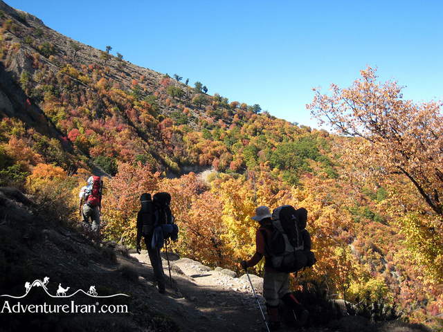
The Valley of Alamut is located in Qazvin province, west of Tehran province. From Tehran city, you have to reach the city of Qazvin where you will find a mountainous road taking you to the height of the Alborz mountains. It takes 4-5 hours to reach the start of the hike which is about 200 km away. The Alamut reminds us of the story of the Castle of the Assassins, (dating back 1,000 years), and the territory of Ismaelies and their famous leader, (Hassan Sabbah). Before beginning the hike, it is recommended you visit the Alamut Castle and stay one night in one of the villages in the valley. The Alamut Valley is located on the southern side of the Alborz mountains. We have to cross the Alborz from the southern side to the northern side to arrive at the Hyrcanian forests and finally reach the Caspian Sea.
There are a couple of routes for hiking from Alamut to the Caspian Sea. The main route was a long hiking trail that a famous British travel writer, (Freya Stark), journeyed through about 100 years ago. She wrote a book about her adventures in Iran which is available in English. Nowadays, the major part of this trail is a paved road.
Most hikers who come here choose an intensive two-day tour which starts from Garmarud village and finishes in Maran. This route crosses two valleys, a canyon, rivers, villages, agriculture regions, and a pass with an altitude of about 3000 m above sea level.

At the end of the hike, it’s possible to stay one day longer by going by car to the Caspian Sea. It is a mountainous road about 60 km long and takes about one and half hours to reach. There are no shelters or camping sites along this trail so you have to stay in a local house or take tents and pitch them yourself on the mountain. The season for hiking in Iran is spring, summer, and the beginning of autumn. This is the link to the selected photos of Alamut valley and the hiking route in the different seasons. Please check the link below:


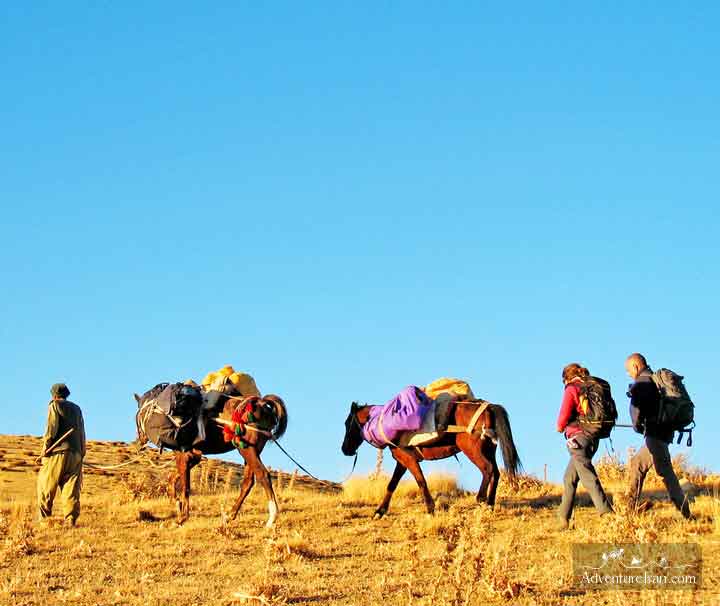
There is another famous hiking trail in Iran, which starts from Alamut and passes MT Alamkuh (4850m) and finishes in Kelardash which is another town 50 km south of the Caspian Sea. This trail is long and takes one week to complete. It is perfect for those who would like to experience something different. You have to possess all the necessary camping equipment for this journey which is carried by a mule. The trail is mostly at a high altitude above 3000 m so you must be prepared for climate change. Summer is the best time for this trip. If you are interested in having more information about the other hiking routes in the Alamut please contact us.
5. Iran’s Off the Beaten Hiking Trails in Highlands of Talesh
Talesh or Talysh is a region in Iran, southwest of the Caspian Sea, located in the northwest of the country. It is a vast valley high in the west Alborz mountains. The inhabitants speak Talysh, a language that also makes up one of the groups of the old Iranian language. Talesh is a unique region in Iran and is perfect for long hikes due to its spectacular landscapes and numerous high-altitude mountains. Most of the semi-nomadic Taleshi people are pastoralists. During the summer they migrate from the lowlands to the highlands with their families and herds of sheep, goats, and cows to pasture. They have a seasonal settlement in the mountains and live a nomadic life there. No official track or hiking trail exists in Talesh. Your hiking trip could last for a couple of days or up to two weeks. It follows the nomads’ path and you can see their tents as you pass through their camping sites.
Hiking in Talesh is one of Off the Beaten regions of Iran, so much so that even most local hikers do not have much information about it. During the hiking trail of Talesh, you will pass a lot of villages, canyons, rivers, and mountains. For adventurous hikers, the end of spring is the best time to travel. You can see a lot of flowers, magnificent landscapes, and locals who start to migrate. However, you have to be prepared for unpleasant weather, as it is often rainy and cloudy at this time. The usual season for hiking is summer.
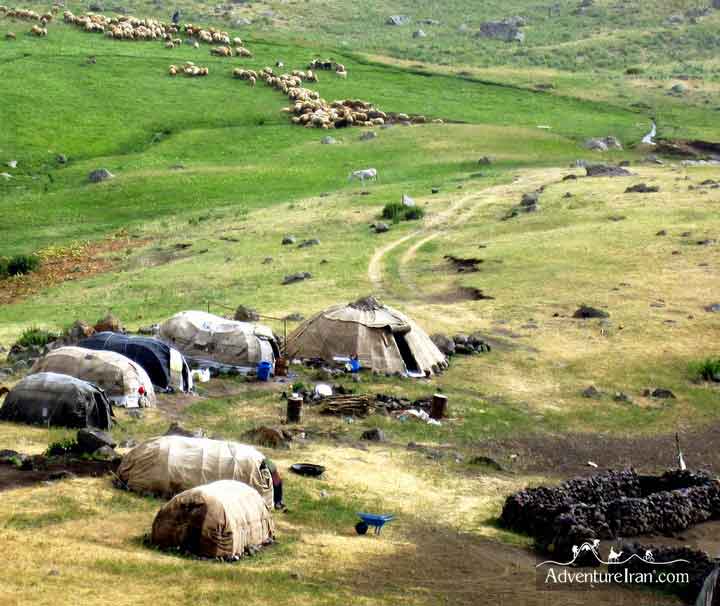
In the summer, the weather is more stable by which time all the locals and nomads have settled down on their land. The climate is sub-tropical with lush green landscapes.
There is a superb photo gallery of Talesh and its nomads on Adventure Iran’s site. Please check the link below:
no images were found
6. Uraman Long Trail – Iranian Kurdistan (UNESCO)
Uraman or Howraman is the name of a region in Iranian Kurdistan which is located in the west of Iran near the Iraqi border. the cultural landscape of HAWRAMAN is the 26th Iranian UNESCO World Heritage site.
The Uraman valley and all its villages have a mountainous climate. From the end of autumn until early spring the mountains are covered with snow. The whole region and Kurdistan province are located in the Zagros mountains. The Iranian Kurdistan province is totally unspoilt.
It is one of the Off the Beaten Tracks of Iran, and is perfect for those who would like to travel to pristine places. Local people are Kurdish with their own language and, of course, their own customs and traditions. In remote villages in Kurdistan, most locals still wear their own traditional clothes, and the colorful dresses of women show how committed they are to preserving their culture. The area is known for its untouched nature, breath-taking landscape, high mountains, beautiful canyons, numerous rivers, rich flora and fauna, their diversity in culture and language and so many other things.
no images were found
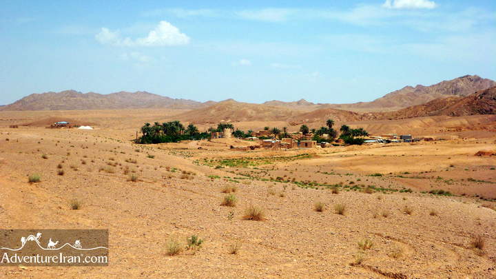
7. Jandaq to Aroosan Hiking (Dasht-e Kavir Desert)
Iran’s deserts are one of the main attractions of the country. Hiking in Iran’s deserts is one of the most amazing and impressive experiences you can have. Jandaq is an old town in the Dasht-e Kavir desert and is located in central Iran. From the two main cities of Esfahan and Yazd on the outskirts of the desert, you can start your hike. The desert is then within easy reach. It is outside Iran’s famous classic route and the main tourist cities. From Esfahan, it takes about 4.5 hours to arrive at Jandaq (370 km), and from Yazd city, there is a desert road, north of the city taking nearly 4 hours (300 km) to reach this village. Jandaq to Aroosan is a long desert hiking trail about 120 km in length that passes through a couple of villages and oases which people still inhabit. There are also a number of guest houses and traditional hotels in the village. It is enjoyable to stay one night in one of these on the way to Aroosan.
You will pass through sand dunes, mountains, a canyon, dry Salt Lake, and a seasonal salty river as well. There are two travel seasons for this area of the desert. Spring and autumn are the best times to hike this trail. In the spring you have more daylight but you have to be prepared for wind and sometimes rain. During autumn you have approximately two hours less daylight compared to spring, but to compensate that the weather is more pleasant for hiking. Compared to other deserts that you may have experienced in other countries, the advantages of being in the Dasht-e Kavir Desert are the varied landscapes, together with meeting local people, which makes this trail more interesting. Two famous travel writers and explorers (Sven Hedin & Alfons Gabriel) crossed this region about 100 years ago and they wrote books about their experiences. Adventure Iran has created two different trips in their names to keep their memories alive.
Sven Hedin Trek and Alfons Gabriel are two tours you can find more information about on Adventure Iran’s website. Also, there is a fascinating collection of our clients’ and our photographers’ photos which were taken during the trips performed over the last 10 years. Please have a look:
no images were found
8. Hiking in Nomadic Tribes of Zardkuh Mountains
Zardkuh (Zardkooh) is the name of mountain chains lying in the heart of the Zagros ranges in the west of Iran. It is in Chaharmahal and Bakhtiari Province which is 200 km away from the west of Esfahan. Zard means yellow and Kuh means mountain. The mountain chain is one of the sources of water in Iran and it is also one of the main sources of two famous rivers of Iran (Zayandeh Rud & Karun).
The region has a high snowfall in winter, and in spring, at the top of the peak, there is still snow to be seen. The mountains have a few peaks above 4000 m and one of them is the second highest peak in the Zagros mountains. Apart from the extraordinary scenery and untouched regions, one of the main attractions of this area is visiting the nomadic tribe who live in the mountains.
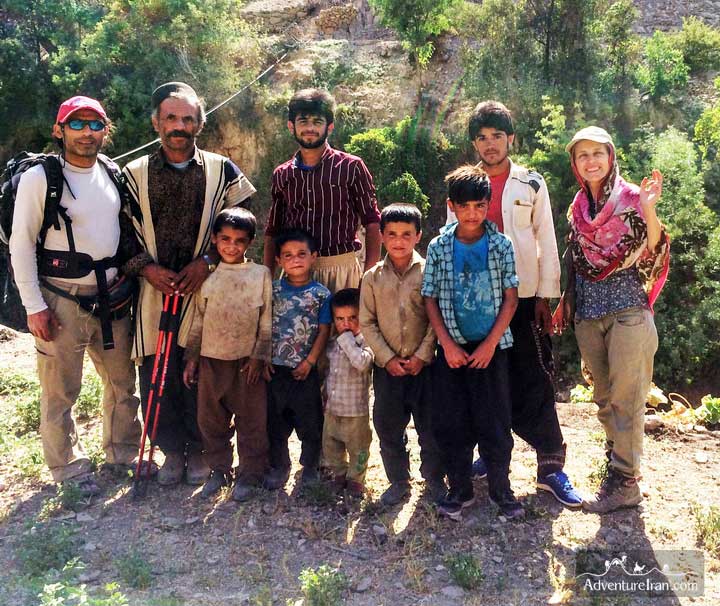
Bakhtaran’s ethnic groups live in the central and southern parts of the Zagros mountains. They migrate to the high mountains from early spring till mid-autumn with their livestock and live there in their special nomadic tents (Siah Chador). Bakhtiari’s nomads belong to Chahar Mahal and Bakhtiari province which is for the most part in the Zard Kuh mountain chains. They have seasonal movement or KOOCH. This tribe has its own customs, dialects, and clothes that vary from other tribes. Bakhtiari’s nomads are chiefly in the west of Esfahan province near Zard Kuh mountain. Here is a link to an interesting gallery of our trip in this region.
no images were found
9. Sarakchal Mountain Ridge
Sarakchal is the name of a 15 km mountain ridge with 4 peaks above 4000 m altitude. It is located in the north of Tehran in the Central Alborz Mountains. The mountains of Srakchal are also at the boundary of the Alborz Markazi protected area. Sarakchal is one of the highest summits in the region with 4210m altitude. It has easy access from Tehran. It is about 60 km away from the center of Tehran, and you can reach there via a mountainous road that goes up to 2600 m.
The last village which is close to the chain is Shemshak village. It is pleasant to stay a night before in this village and acclimatize before the next day ascend. Shemshak is famous because it was the first Iranian ski resort, made before the Iran revolution, which opened in 1958. The best time for hiking is summertime, as the weather is more stable and by then the snow on the peak will have melted. It is also advisable for professional hikers, who are able to hike in different and more difficult situations, to come at the end of spring and the beginning of autumn.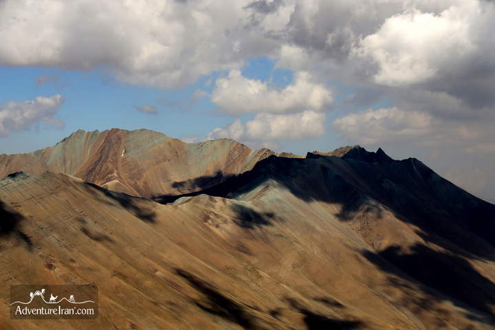
It is more beautiful than summertime. This is the link to the photos of hiking in Sarakchal at various times of the year:
no images were found
10. Iran Off the Beaten Hiking Trails in Jahan Nama protected area
Jahan Nama is a protected area which is located in Golestan Province in the southeast of the Caspian Sea. It has picturesque landscapes and rich wildlife, including wild sheep and goats, wolves, panthers, bears, weasels, owls, eagles, and porcupines.
Jahan Nama is also famous for its variety of plants and trees, including barberry, Sorkhdar, Kolah-e Mir Hassan, Bolandmaza Namdar, Borage Cowslips, Ras, Darmaneh, and many others.
There are also countless seasonal birds in the park, and numerous rivers and springs. Jahan Nama’s pristine nature has made it an ideal hiking destination. We, at Adventure Iran, have created a long hiking trail that starts from the south of the Great Gorgan Wall and stretches all the way to the Jahan Nama Park.
no images were found
For more information about Iran Trekking Tour, please check out bellow VIDEO GALLERY![]()
For more information about the most famous Iran Mountains, please check the following link:
Comments