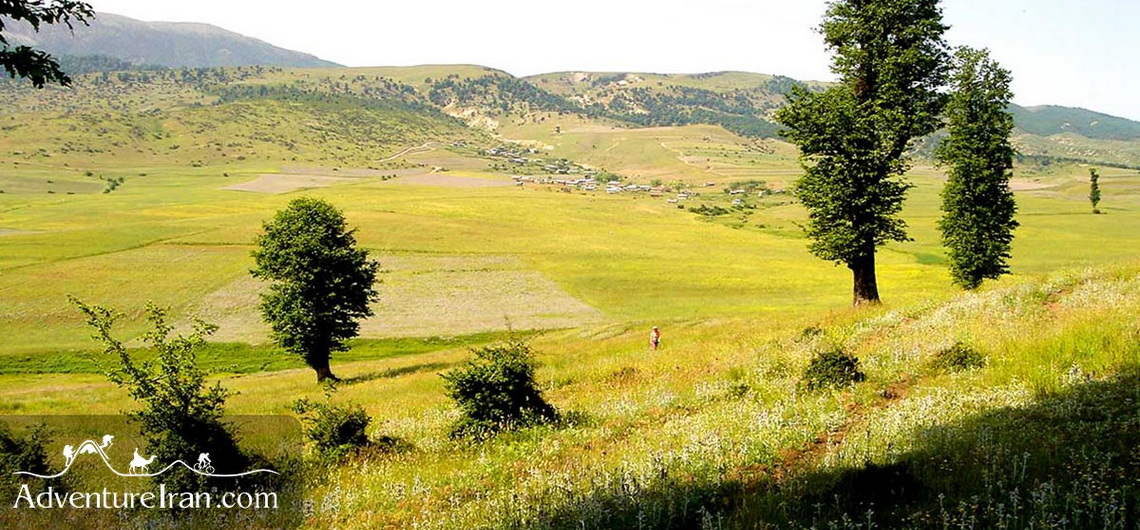
Jahan Nama Protected Area A small village of Jahan Nama by the Caspian Sea gave the name to the vast Jahan Nama Protected Area in the Golestan Province in Iran. With rich wildlife, including wild sheep and goats, wolfs, panthers, bears, weasels, owls, eagles, cuckoos, woodpeckers, and porcupines, Jahan Nama is also famous for its variety of plants and trees, including barberry, Sorkhdar, Kolah-e Mir Hassan, Bolandmaza Namdar, Borage Cowslip, Ras, Darmaneh, and many others. During the studies performed here between 1999 and 2008, 1,350 species were identified, including 607 vascular plant species from 85 families. There are also many seasonal birds in the park and a lot of rivers and springs. The highlands of Jahannama are the most suitable habitats for various hunting birds such as the golden eagles, as well as large partridges. Jahan Nama Park, with an area of about 38 ha, is the largest protected area in Mazandaran province, after Golestan National Park. It is part of the Hyrcanian forests (UNESCO), which are among the oldest forests in the world. The beauties and attractions of the Jahan Nama region are not only limited to its rich flora and fauna and intact nature. The 35-meter Radkan Tower, also known as Mil Radkan, is one of the main historical attractions in this area. It is a cylindrical brick tower dating back to the 13th century. Ziarat Waterfall is another natural attraction in the northeast of the region, located about 5km from Ziarat Village. The village is one of the most beautiful tourist villages in Iran. The pristine nature of the park makes it an ideal hiking destination and we, at Adventure Iran, have created a long hiking trail, which starts south of the Great Gorgan Wall and stretches all the way to the Jahan Nama National Park.
Jahan Nama Protected Area A small village of Jahan Nama by the Caspian Sea gave the name to the vast Jahan Nama Protected Area in the Golestan Province in Iran. With rich wildlife, including wild sheep and goats, wolfs, panthers, bears, weasels, owls, eagles, cuckoos, woodpeckers, and porcupines, Jahan Nama is also famous for its variety
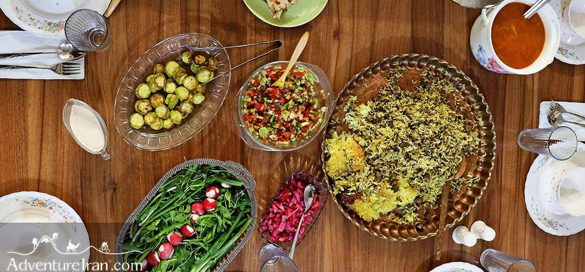
Iranian Foods and Persian Cuisine Iran has numerous ethnic groups and tribes in its vast and historic land. Each ethnicity and tribe have its own traditional food according to geography and climate. The type of Iranian foods and Persian cuisine in the hot regions such as the Iran Deserts is very different from the northwest of Iran with its cold temperature. It also varies from the vegetarian food of the Caspian Sea to the spicy seafood of the Persian Gulf. The idea behind these distinct Persian dishes is not only to provide an endless variety of tasty recipes but, more importantly, for the food to have nourishing properties, using special herbs, to ensure a healthy body. To achieve this, it is vital to understand how traditional food was selected to suit the varying climatic conditions. The out-of-the-ordinary delicious Persian cuisine, combined with the colors of Iranian food, is for us the art of cooking. In our tradition, which goes back centuries, the hot and cold nature of the body and its temperament were taken into consideration when it was determined what to eat and where. This was to control the balance of this system. The ingredients, the root of everything we eat, are essential to keep our bodies from preventing illnesses rather than curing them. We are thankful and proud of our Persian medicine, developed over two thousand years, which is included in our every meal. In Iran, we call it ‘Iranian Traditional Medicine’, where some of our universities offer various programs about this ‘traditional medical science’. Not only, but also, this history of the hot and cold nature of our bodies has been followed by other traditions of medical science such as the Chinese, Greeks, Romans, etc. ‘Avicenna’ was an outstanding and highly admired Persian scientist who was and
Iranian Foods and Persian Cuisine Iran has numerous ethnic groups and tribes in its vast and historic land. Each ethnicity and tribe have its own traditional food according to geography and climate. The type of Iranian foods and Persian cuisine in the hot regions such as the Iran Deserts is very different from the northwest
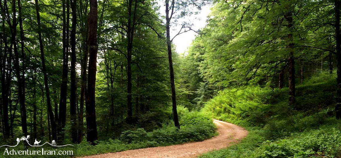
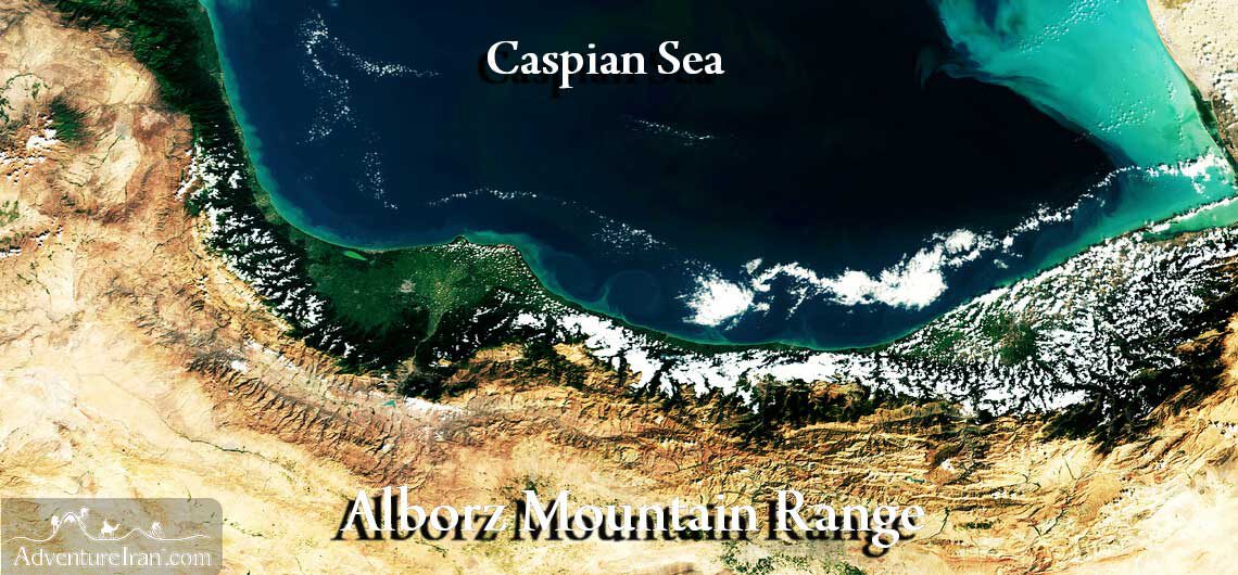
Hyrcanian Forests in Iran (UNESCO) Iran has a large number of national parks and protected areas, including two Natural UNESCO World Heritage Sites, one of which is the Caspian Hyrcanian Forests. Located in northern Iran along the southern coast of the Caspian Sea and the northern slopes of the Alborz Mountains, the forest covers an area of 850km and, from a historical perspective, dates back to 25 to 50 million years ago. Hyrcanian Forests in Iran were registered as the second natural site of Iran on UNESCO World Heritage List in 2019. The forests are named after the ancient region of Hyrcania, a historical region extended from southeast of the Caspian Sea in Iran and Turkmenistan. Hyrcanian Forest represent one of the planet’s oldest and most ecologically significant temperate forests. These lush woodlands of Hyrcanian forests survived the Ice Age, creating a living museum of biodiversity. Hyrcanian forests are home to 180 species of birds including Steppe Eagle, European Turtle Dove, Eastern Imperial Eagle, and Caspian Tit, as well as 58 species of mammals, including Panthera pardus tulliana (Persian leopard), and Wild Goat, while they only cover 7% of the country. The forest is extended across three Provinces of Gilan, Mazandaran, and Golestan, and part of that covers the southeast part of the country of Azerbaijan. One of the habitats of this rare species is Jahan Nama protected area, that Adventure Iran’s “The Red Snake Wall and the Turkoman Plain” tour lies through. Why Are They Unique? Primeval Ecosystem: Home to 1,800+ plant species (including Persian ironwood and Caspian beech) and rare wildlife like the Caspian tiger (extinct) and Persian leopard (critically endangered). Climate Resilience: Their layered canopies and humidity trap moisture, forming a "green belt" that cools the region. Cultural Ties: Local communities, like the
Hyrcanian Forests in Iran (UNESCO) Iran has a large number of national parks and protected areas, including two Natural UNESCO World Heritage Sites, one of which is the Caspian Hyrcanian Forests. Located in northern Iran along the southern coast of the Caspian Sea and the northern slopes of the Alborz Mountains, the forest covers
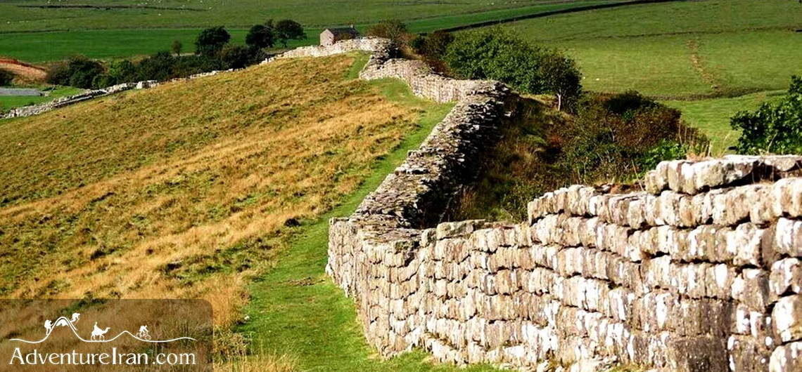
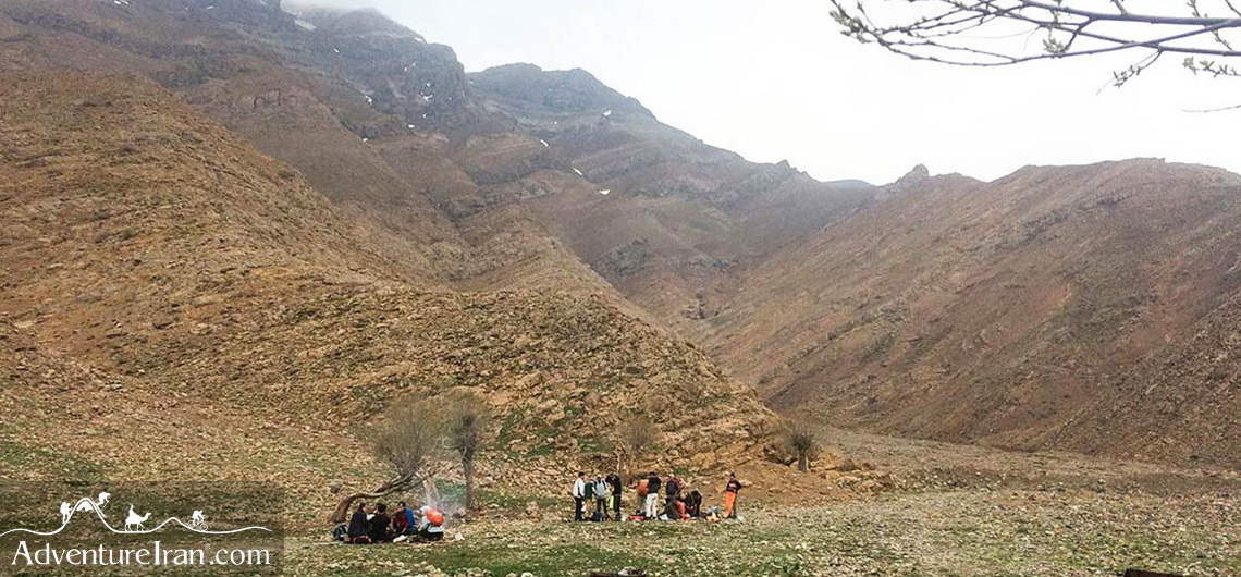
Great Wall of Gorgan The remains of the Great Wall of Gorgan, also known as “The Red Snake Wall” due to the color of its bricks, are located in northern Iran in the Golestan Province. Dating back to the Sasanid dynasty, the wall was originally built in approx. 420-530AD, which makes it 1,000 years older than the Great Wall of China. It has the remains of 38 fortifications and stretches for almost 200km. The Wall is believed by some to be the longest manmade ancient barrier between Central Europe and China and even longer than the Hadrian’s Wall and the Antonine Wall put together. Since there was not any stone or timber in the area, the wall was constructed with bricks. Substantial sections of the Great Wall of Gorgan appear, however, to be buried under the Caspian Sea. Together with the Tammisheh Wall, a shorter defensive barrier of similar design, also dating from the Sasanid time, both walls were part of the same defense system and were built of large fired bricks of similar shape and size and lined by an earth bank and ditch supplied with water by the canals. The canals bridged the Gorgan River via qanats. The Wall and the canals prove the hydraulic engineering skills of the Iranians in the Sassanid era. https://www.adventureiran.com/golestan-province-and-turkmen-plain-tourist-highlights/ https://www.adventureiran.com/golestan-national-park/
Great Wall of Gorgan The remains of the Great Wall of Gorgan, also known as “The Red Snake Wall” due to the color of its bricks, are located in northern Iran in the Golestan Province. Dating back to the Sasanid dynasty, the wall was originally built in approx. 420-530AD, which makes it 1,000 years older
Dasht-e Havij in Iran Dasht-e-Havij or Gor Chal plain, at an altitude of 2,700 m, is situated 400 meters above Afjeh village in Iran. It is one of the most famous attractions in the Lavasanat district (northeast of Tehran in the central Alborz Mountains). Havij means Carrot and Dasht-e Havij means literally a ‘big carrot field’. There are various legends about this name’s origin, which probably indicate that large parts of this vast land were sown with carrot seeds. Today, there is no sign of anything left to reinforce it. Gor Chal in ancient Persian means fireplace, being the combination of two words; Gor means fire and Chal means place. It is said that it got its name for it being so hot compared to the surrounding places being so cold, but there is no evidence to support this assertion. Dasht-e Havij is surrounded by a cluster of high-altitude peaks between 3,000 – 4,000 m which protects this area from the wind. During the Safavid dynasty (400 years ago), it was an important hunting area with some beautiful cascades called Passchoobak, Saboosetan, and Charand. A couple is still in existence, depending very much on the snowfall of that year. In addition, there are numerous maple trees and, of course, a variety of fruit trees in this unspoiled region. The remains of Safavid Caravansaries can be seen along the path at the end of the valley, near the rock wall. There is also an old bath dating back to the Safavid era which is, surprisingly, still in use and is presently enjoyed by rural people. The Qajar dynasty (200 years ago) used this path to reach the Lar National Park going through the countryside. From Lar, there was an ancient mule road stretching towards the Caspian Sea. 3 Peaks in
Dasht-e Havij in Iran Dasht-e-Havij or Gor Chal plain, at an altitude of 2,700 m, is situated 400 meters above Afjeh village in Iran. It is one of the most famous attractions in the Lavasanat district (northeast of Tehran in the central Alborz Mountains). Havij means Carrot and Dasht-e Havij means literally a ‘big carrot
Highlands of Talesh in Iran Talesh also spelled Talysh and Talish, is a region in northwest Iran, west of the Alborz Mountain range along the southwest of the Caspian Sea. The Talesh area is believed to be the place where the Aryan People first settled (They are Indo-European people who moved down from, what are today, the Russian steppes to Europe, Iran, Central Asia, and northern India in the second millennium BC). It is also said to be the birthplace of Zoroaster, the prophet of the ancient Persian religion, Zoroastrianism. Talesh has a sub-tropical climate with a lush green landscape. The region can be divided into two parts, the lowlands, and the highlands. The lowlands lie along the fertile coastal plain of the Caspian Sea and are abundant with rice paddies and orchards. The highlands constitute almost three-quarters of the area of Talesh and are covered by dense deciduous forests and meadows. The Talesh massif forms a 300 km long natural barrier against the drier climate to the south and west. Its highest peak, Bagharo Dagh, is at an altitude of 3,200 meters. The people of Talesh have their own distinct language and culture which have been preserved over the centuries by the remoteness of their land. A great number of them are pastoralists and semi-nomadic. They migrate to the highlands with their herds of sheep and goats every spring to pasture. They live in wooden houses or a kind of fixed tent, called Kapar, in their summer encampments. During this undiscovered superb trek, we will experience their genuine hospitality firsthand by staying and eating with them or camping next to them. Talesh has wonderful mountainous areas and its virgin and intact nature is a charming place for those eager to immerse themselves in it. Talesh is situated 140
Highlands of Talesh in Iran Talesh also spelled Talysh and Talish, is a region in northwest Iran, west of the Alborz Mountain range along the southwest of the Caspian Sea. The Talesh area is believed to be the place where the Aryan People first settled (They are Indo-European people who moved down from, what are
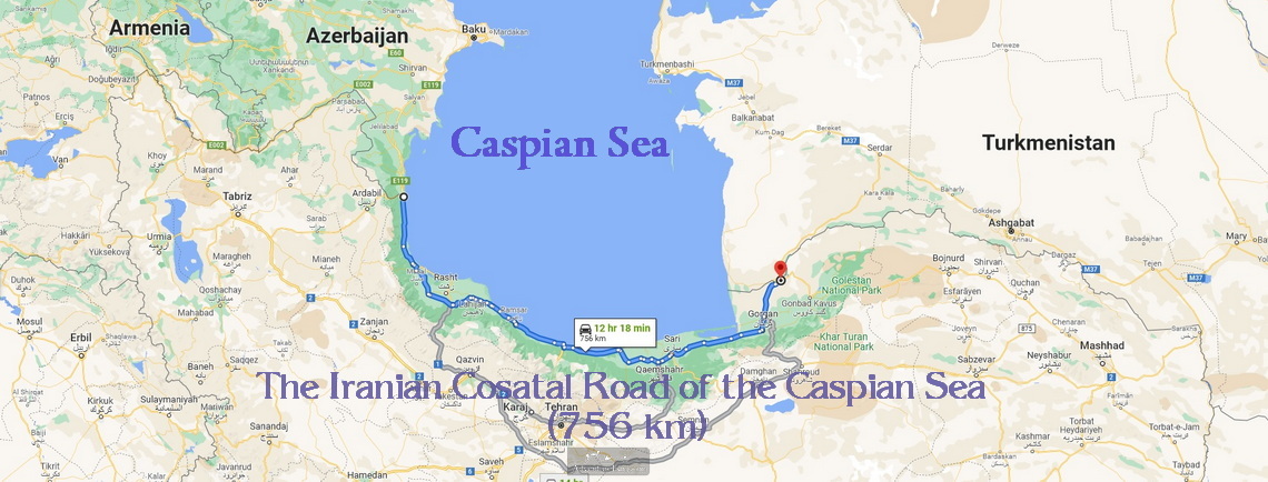
The Caspian Sea North of Iran The Caspian Sea is the largest lake in the world, situated in south-eastern Europe and south-western Asia. It is surrounded by 5 different countries, Kazakhstan, Russia, Azerbaijan, Turkmenistan, and Iran. The Sea is home to a wide range of species. More than 850 different animals and at least 500 different types of plants live in this sea. However, the diversity of species can be considered almost too low for the size of this water body, most of them being indigenous like caviar. In Persian, the Caspian Sea is called Daryaye Kahzar, which is doubtlessly one of the most beautiful parts of Iran. In the summertime, millions of people from all over the country, especially Tehran, travel to this coast. In Iran, it is also known as Shomal-e Iran meaning Northern Iran, an area along the coast of the Sea. The forested coastal plains rise up to the Alborz Mountains. This region consists of the three provinces of Gilan, Mazandaran, and Golestan, each with plenty of attractions. The climate of the southern Caspian Sea is perfect for agriculture. There is an abundance of fruits, vegetables, and herbs as well as rice and tea, so important to Iranian culture. Northern Iran, to the south of the Sea, is the rainiest region. In addition, the area is located in the northern part of the Alborz Mountain Range with a lot of high-altitude mountains, where melted snow has created splendid rivers. Furthermore, there are many exquisite dense forests between the Alborz Mountains and the Caspian Sea. One of the most famous is the Hyrcanian Forests, registered on the list of UNESCO natural sites. There is also another UNESCO site in this region. Gonbad-e Qabus tower is a UNESCO world heritage site, being the tallest pure-brick tower in
The Caspian Sea North of Iran The Caspian Sea is the largest lake in the world, situated in south-eastern Europe and south-western Asia. It is surrounded by 5 different countries, Kazakhstan, Russia, Azerbaijan, Turkmenistan, and Iran. The Sea is home to a wide range of species. More than 850 different animals and at least 500 different
Alborz Mountain Range Alborz mountain range is a major mountain range in Northern Iran, located south of the Caspian Sea. In Persian it’s called Resht-e Kouh-hayeh Alborz. There are various spellings of these mountains as follows: Elborz, Alburz, Albourz, and Elburz. The length is around 900 km, stretching from Azarbaijan, (“northeast Iran”, close to the Turkish border), all the way to the Khorasan region in “northwest Iran.” There are many rivers, hot and cold springs, lakes, amazing canyons, national parks, protected areas, wild life, birds, a wide range of forests similar to Hyrcanian forests, “UNESCO natural sites”, waterfalls, and ski resorts in this enormous mountain range. In addition, there are human settlements inhabited by nomads. The mountains, alongside the south side of the Caspian Sea, formed a special ecosystem with particular weather conditions. Surprisingly, the flora on the northern side of the mountain range are quite different from that of the south. There is an abundance of high-altitude mountains above 4,000 m which is the home base for Iranian adventurers; e.g. trekking, mountain biking, Ultra Trail Running, ice climbing, mountaineering, rock climbing, rafting, ski and ski touring. For those who thought Iran to be a flat, desert like country, it’s interesting to know there are 148 mountains above 4,000 m registered in Iran, the majority being located in the Alborz mountains. The three main highest peaks are in this range. There are several mountain clubs in this country catering for all types of mountain activities during the yearly seasons. Iranian climbers are also active in ascending the renowned Himalayas. Alborz mountain range is categorized as three different segments due to its geographical sector, Western, Central, and Eastern Alborz. Each section of this mountain range has its own unique beauty. Adventure Iran conducts a variety of activities in
Alborz Mountain Range Alborz mountain range is a major mountain range in Northern Iran, located south of the Caspian Sea. In Persian it’s called Resht-e Kouh-hayeh Alborz. There are various spellings of these mountains as follows: Elborz, Alburz, Albourz, and Elburz. The length is around 900 km, stretching from Azarbaijan, (“northeast Iran”, close to the
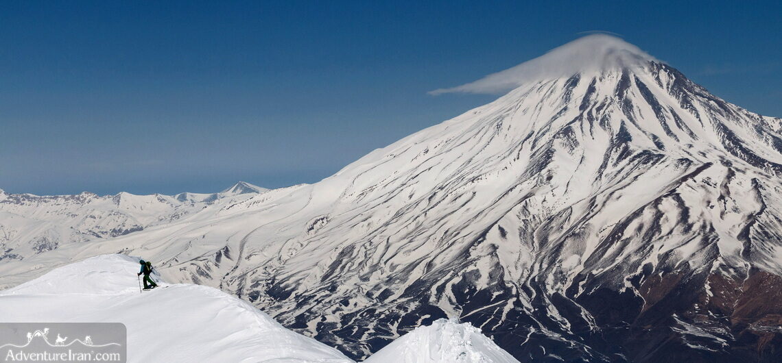
Mount Damavand Iran's Highest Moutain (5610m) Mount Damavand is the highest mountain in Iran and the whole Middle East. It is also the highest volcanic cone-shaped peak in Asia. Located 104km northeast of Tehran in the Central Alborz Mountains, thanks to its volcanic nature Damavand and its surrounding area are rich in hot and cold springs. Large sections of the mountain’s slopes are covered with sulphur, which explains the sulphur odour. There are also glaciers, waterfalls and geysers. The peak of Damavand covers permanently snow during the entire year. The most important thermal springs are Ask and Larijan. The Flora and Fauna is very rich and include about 2000 plant species. There are numerous endemic species which are important to Flora of world. There are 16 recognized routes for ascending the Damavand peak and many accounts and stories from many those who have reached the summit. The mountain itself is subject of many mythical and folkloric tales. Damavand slopes are most beautiful in the spring and the views from the top are breathtaking, the Caspian Sea to the north, the Lar Lake and the sprawling city of Tehran to the west and vast Dasht-e Kavir desert to the south. The ascent will be truly memorable and enjoyable. The most popular ascent route is along the Damavand’s southern slope. Here there are more facilities, Iranian mountaineering federation base camps and 4x4 vehicle access to the 2nd base. Before ascending Damavand, one must first complete the acclimatization program. Why Mount Damavand is a Must-Visit for Adventure Enthusiasts Mount Damavand, standing tall at 5,610 meters (18,405 feet), is not only the highest peak in Iran but also the highest volcanic summit in Asia. Located in the Alborz Mountain Range, this iconic stratovolcano is a dream destination for hikers, climbers, and
Mount Damavand Iran’s Highest Moutain (5610m) Mount Damavand is the highest mountain in Iran and the whole Middle East. It is also the highest volcanic cone-shaped peak in Asia. Located 104km northeast of Tehran in the Central Alborz Mountains, thanks to its volcanic nature Damavand and its surrounding area are rich in hot and cold
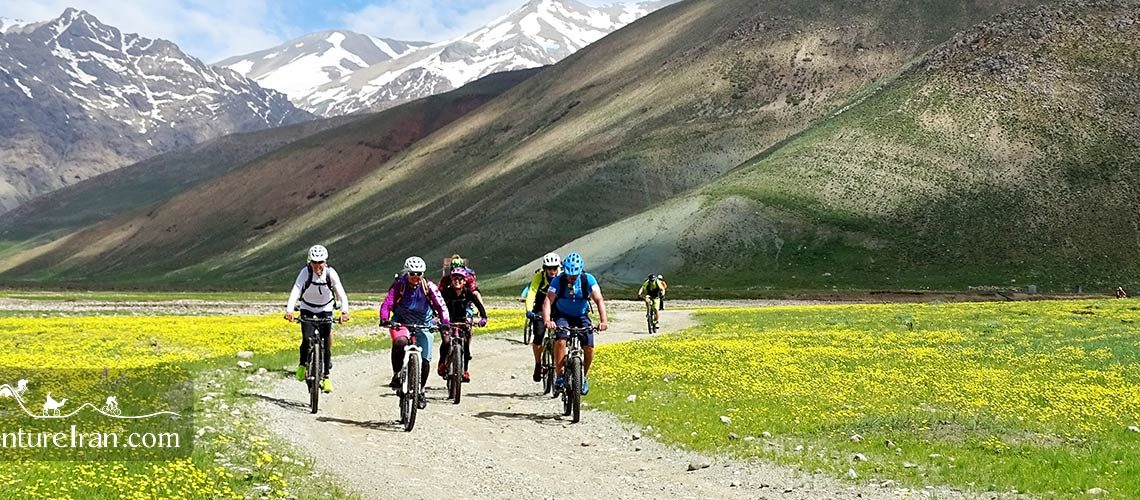
Mountain Biking in Iran Mountain Biking in Iran is a new activity for adventure travelers who come from all around the world. Iran is really an ideal mountain biking destination, but, unfortunately, it is not yet covered in the press and media. There are many Mountain Biking clubs, and over the past ten years, this challenge has appealed to a lot of women. Mountain Biking is not a popular activity as it is in some countries in Europe; there is not an exclusive cycling path in the streets of Iran. The mountains offer a lot of good trails and single-track roads which are proper for MTB freaks. There are a lot of dirt roads in our deserts between the villages and also single trails between oases which are perfect for this sport. We also have very decent roads with good quality asphalt in most parts of the country. As Iran is a mountainous country the roads are not flat so you will experience a lot of ascent and descent in most of them. We have created a wide range of mountain biking Iran tours from the Persian Gulf to the Caspian Sea. Iranian Coast to Coast by Bicycle tour is one of the good examples of our various mountain biking tours. If you check the CYCLING tour tab below the Iran Tours menus in the Adventure Iran website, you will find our Mountain Biking tours from January to December. In spring, we conduct most of our mountain biking tours in central Iran, where there are mountains and deserts. In summertime, we send our adventurous riders to the high peaks and sometimes to the Caspian Sea. Our mountain biking tours in autumn could take place in various regions. Autumn is a desert season. Desert of Iran “Dasht-e Kavir
Mountain Biking in Iran Mountain Biking in Iran is a new activity for adventure travelers who come from all around the world. Iran is really an ideal mountain biking destination, but, unfortunately, it is not yet covered in the press and media. There are many Mountain Biking clubs, and over the past ten years, this