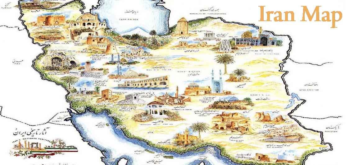
Iran’s Non-Tourist Destinations A Guide to the Hidden Side of Persia For travelers seeking a deeper connection with Iran beyond its famous historical sites, Iran non-tourist destinations offer a rare chance to explore untouched landscapes, remote villages, and authentic cultures. These locations remain undiscovered by mass tourism, making them ideal for adventure seekers, photographers, and cultural enthusiasts. Why Explore Non-Tourist Destinations in Iran? •Authenticity – Experience Iran as it truly is, far from commercialized attractions. •Solitude – Escape the crowds and immerse yourself in pure nature and history. •Adventure – Discover unique landscapes, from deserts to mountains, islands, and jungles. •Cultural Encounters – Meet local ethnic groups and nomadic tribes that preserve ancient traditions. Here’s a curated list of non-tourist destinations in Iran, categorized by region and landscape: 🏜️ Remote Deserts & Salt Flats 1. Gandom Beryan, Lut Desert (Kerman Province) Considered the hottest place on Earth, Gandom Beryan is a vast volcanic rock-covered desert with temperatures reaching 70°C in summer. Its black lava fields and endless horizons create a surreal landscape for extreme adventurers. Gandom Beryan and Lut Desert are one of Iran's off the tourist path and is one of main Iran's natural wonders. 2. Koreh Gaz and Aroosan Villages (Isfahan Province) Far from the crowded tourist camps of Varzaneh and Maranjab, these tiny desert settlements provide an untouched experience of Iran’s Dasht-e Kavir. Camel treks, salt dunes, and absolute silence make this area a dream for desert lovers for those who are looking a NON-Tourist traveling path of Iran. 3. Shahdad Kalouts (Beyond the Main Route) (Kerman Province) While some visitors reach the edge of the Kalouts, the real magic happens deep inside this wind-sculpted desert, where massive sand formations create an otherworldly maze. Only accessible with an experienced guide. 4. Haj Aligholi Salt
Iran’s Non-Tourist Destinations A Guide to the Hidden Side of Persia For travelers seeking a deeper connection with Iran beyond its famous historical sites, Iran non-tourist destinations offer a rare chance to explore untouched landscapes, remote villages, and authentic cultures. These locations remain undiscovered by mass tourism, making them ideal for adventure seekers, photographers,
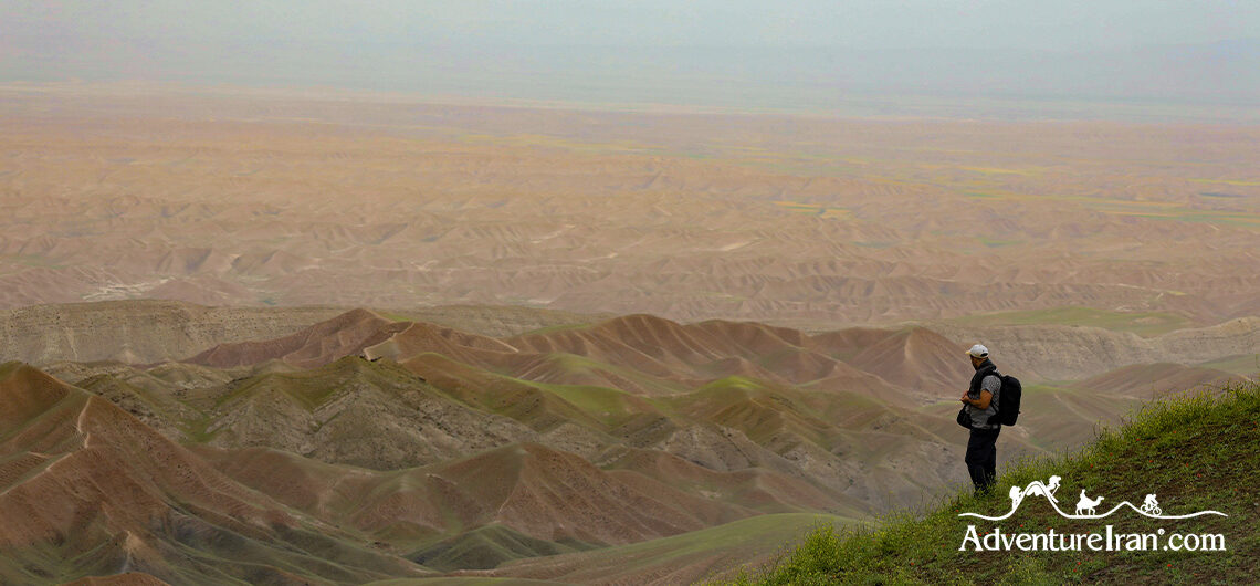
Dena Protected Area Introduction Dena Protected Area is one of Iran’s most preserved environmental regions managed by the Iranian Environmental Organization. There’s also a special ecodiverse zone inside this protected area called Dena National Park. The park was registered on the list of biosphere reserved regions of UNESCO in 2010. Dena Protected Area is nestled in the Dena Mountain Chain, one of the longest chains of the Zagros Range. Dena location and how to reach it Dena Protected Area, situated in the south-west of Iran, is approximately north of Shiraz province. This protected area with 255,537.00 ha (2555 square kilometres) is located in the two provinces of Kohgiluyeh and Boyer-Ahmad and Isfahan. It’s about a 2.5-hour drive of 200 km from Shiraz city on a beautiful mountain road. You can also reach Dena from the north of Isfahan city, a drive of about 310 km taking about 4.5 hours and passing through a network of tunnels. Dena Geographical specification Dena Protected Area is situated in a specific geographical location of the Zagros Mountain range which has different terrains. The lowest part of the Dena Protected Area is located in the agricultural area and starts at an altitude of 1300 m. The land goes up to an upper altitude reaching the forest close to the Dena Mountain foothills. This region has an altitude between 1800m to 2500 m covered mostly with oak trees with a wide range of flora and fauna. The upper part of Dena protected land is a mountainous region which is above 3000 m. In this area you will find a lot of canyons, waterfalls, and glaciers, making it an exceptional place for wildlife. These three different ecosystems have created a unique destination for those of you who would like to experience the extra-special
Dena Protected Area Introduction Dena Protected Area is one of Iran’s most preserved environmental regions managed by the Iranian Environmental Organization. There’s also a special ecodiverse zone inside this protected area called Dena National Park. The park was registered on the list of biosphere reserved regions of UNESCO in 2010. Dena Protected Area is
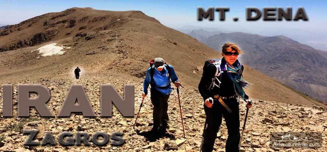
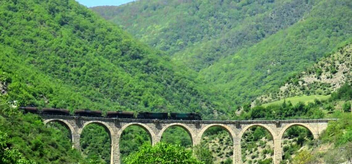
Dena Mountains and National Park Trek Dena is the name of a mountain chain located in the middle part of the Zagros mountain range in Kohgiluyeh and Boyer-Ahmad Province of Iran which is in the north of Shiraz province. The length is about 90 km with 40 mountains above 4000m and it's one of the best locations for Trekking in Iran. On the foothills of the chains, there is a national park with the same name (DENA) which is a protected area and home to a lot of wild animals with a rich environment as it has a lot of plants and a huge oak forest. It's under the conservation of the Iran Environment Organization. Dena region is a very important destination as it is between the two main touristic cities of Shiraz and Isfahan and it’s a marvelous location for those who are interested in hiking in Iran and would like to combine it with Iran Classic Routes. It's the perfect itinerary for Iran first-timers who want to do Cultural and historical tours along with Iran's main UNESCO Heritage sites. Adventure Iran is the first company to create different trekking routes in this region for different fitness levels from a 2-day moderate trek up to a one-week challenging trek on the ridgeline to ascend a few peaks above 4000 m. We have also made a few trips which are a combination of trekking and cultural explorations. Some tours start from Shiraz and some of them start from Tehran. The clip is a short slideshow from a few of our trips that we performed in different years for hikers from different countries and it just gives you an idea about the scenery and landscape of this amazing destination. For those who are interested in moderate treks, we recommend our trip
Dena Mountains and National Park Trek Dena is the name of a mountain chain located in the middle part of the Zagros mountain range in Kohgiluyeh and Boyer-Ahmad Province of Iran which is in the north of Shiraz province. The length is about 90 km with 40 mountains above 4000m and it’s one of the
How to Create a Successful Travel Itinerary for Iran? One of the main questions for many tourists, travel agencies, or tour operators is : How to make an efficient travel itinerary to cover the most important Iran attractions on a short trip? Please continue reading this very useful article if you would like to have the Best Iran Tour during your holiday. Most travelers don’t have much information about the huge size of the country. The distance between main touristic cities, the number of UNESCO heritage sites, the diversity of Climate and Weather in Iran, or the types of activities they could have in Iran have variations too. Persian arts, type of transport, the best time for traveling in Iran for different regions, Persian cuisines and Iranian home foods, and off the beaten track destinations of Iran are important in this list too. Especially for those who are first-timers in Iran, having this information could be beneficial in creating a perfect travel holiday for Iran. Instead of proposing a couple of template travel itineraries to answer the above question, we try to explain a few essential topics to help you in finding the answer. 1. Huge Size of the Country and the Distances Iran is a very vast country that is much larger than most European counties. To have a better image of the country, Iran is around the size of Germany, France, Italy, Netherlands, Belgium, Czech, Slovakia, Austria, Switzerland, Croatia, and Slovenia together. We give you another example for you to understand this better. There is a famous route from northwestern Iran to Southeastern Iran called the One-Month Classic Overland Route of Iran, which starts from the Turkish border and finishes at the Pakistani border in the southeast of the country. The direct distance of that route from
How to Create a Successful Travel Itinerary for Iran? One of the main questions for many tourists, travel agencies, or tour operators is : How to make an efficient travel itinerary to cover the most important Iran attractions on a short trip? Please continue reading this very useful article if you would like to have
Iran Turkmen Plains Golestan Province Tourist Highlights Stretching across Golestan Province in northeastern Iran, the Turkmen Plains (Dasht-e Turkmen) offer a captivating blend of vast grasslands, nomadic traditions, and unique biodiversity. This lesser-known region is home to the Turkmen people, whose vibrant culture—seen in their handwoven carpets, spirited horse games (Buzkashi), and distinctive yurt dwellings—adds rich authenticity to the landscape. The plains merge seamlessly with the Golestan National Park, a UNESCO Biosphere Reserve, where visitors can spot rare wildlife like the Persian leopard and wild sheep. Ideal for off-the-beaten-path adventures, the Turkmen Plains invite travelers to experience horseback riding, nomadic homestays, and the annual Turkmen Silk and Spice Festival. Whether you’re a culture enthusiast or a nature lover, this frontier region promises an unforgettable glimpse into Iran’s diverse heritage. Golestan province is one of the untraveled routes of Iran offering a wide range of attractions, activities, and tourist highlights. It is located in the southeast of the Caspian Sea, and southern part of Turkmenistan country. Golestan means the land of flowers. The rural parts of this province are rich in flora and fauna, and you will be amazed at its variety of animal and plant species. In fact, Golestan province is one of the greenest parts of Iran. Golestan Main Tourist Highlights Golestan National Park Golestan National Park is one of the tourist highlights of Golestan province which enjoys remarkable ecosystem diversity. There is a large variety of wildlife in the park, and a huge variety of birds live there. Golestan National Park is the largest and oldest national park in Iran. The park is a protected area managed by the Iranian Environmental Organization. Along with the natural attractions, there are many other historical and cultural attractions in Golestan province too. Gonbad-e Qabus (UNESCO) Gonbad-e Qabus also
Iran Turkmen Plains Golestan Province Tourist Highlights Stretching across Golestan Province in northeastern Iran, the Turkmen Plains (Dasht-e Turkmen) offer a captivating blend of vast grasslands, nomadic traditions, and unique biodiversity. This lesser-known region is home to the Turkmen people, whose vibrant culture—seen in their handwoven carpets, spirited horse games (Buzkashi), and distinctive yurt dwellings—adds
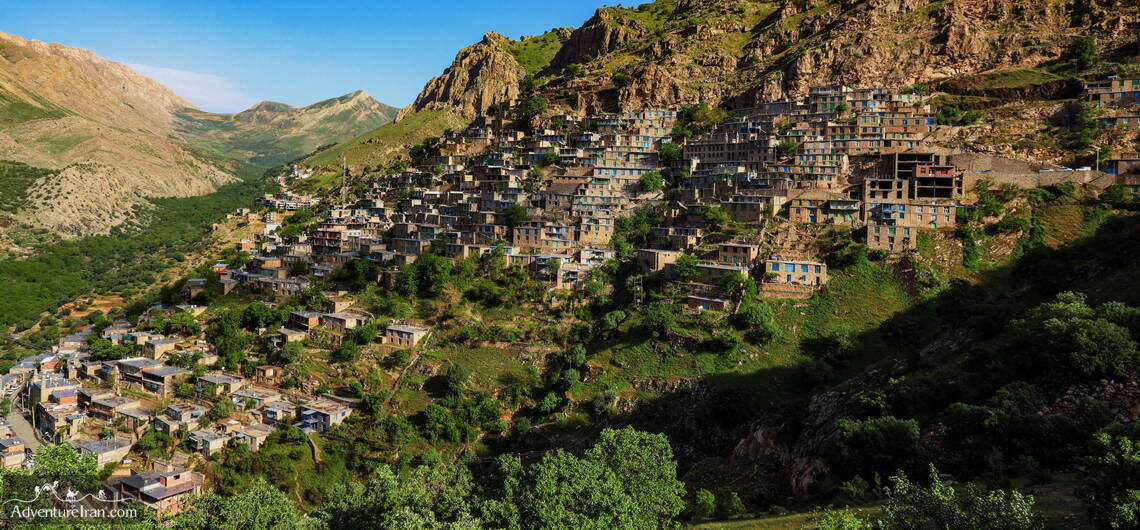
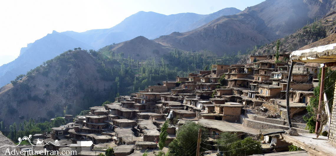
Oraman (Uraman) Takht Village in Iran (UNESCO) Oraman or Uraman-e Takht is the name of a village located in Hawraman in the Kurdish region of Iran. The Cultural Landscape of Hawraman was registered in the list of Iranian UNESCO sites in July 2021. Hawraman is the name of the valley and mountain region located within the provinces of Kurdistan and Kermanshah in western Iran and the north-eastern Kurdistan Region in Iraq. The majority of the property of Hawraman is situated in Iran. Only a small northern part of this valley is located in Iraq. The Oraman village is one of the most exotic villages in Iran. It is 63 km away from the south of Marivan, Kurdistan Province, in Iran. Uraman Architecture The village stone houses are stair-like fashion, with beams covering the ceilings. Here, the roof of one house is the courtyard of the other. There are many other villages in Hawraman and other parts of Kurdistan with similar architecture. The following villages' pictures present the traditional architecture of this region of Iran. Uraman Attractions Oramanat Takht village is undoubtedly one of the attractive rural areas of Kurdestan. It is also among the Top 10 Iran Tourist Villages. The spectacular panoramic views of this area, like the rivers in the valley, are not the only attractions. Kurdish old traditions, such as Kurdish dance, traditional clothes, and customs are other attractions unique to the region. The annual performance of an ancient wonderful ceremony of Pir Shalyar put this village on the list of best Iran villages as well. Ancient fire temples and remnants of this region indicate that the inhabitants were Zoroastrian before converting to Islam. The fertile lands here are full of walnut, pomegranate, fig, and mulberry trees. The tomb of Pir Shalyar (Peer Shahriar) is one of
Oraman (Uraman) Takht Village in Iran (UNESCO) Oraman or Uraman-e Takht is the name of a village located in Hawraman in the Kurdish region of Iran. The Cultural Landscape of Hawraman was registered in the list of Iranian UNESCO sites in July 2021. Hawraman is the name of the valley and mountain region located within
Iran Top 10 Off the Beaten Paths You Should Visit! Iran is a vast country with a wealth of impressive tourist attractions. You will be amazed at the long list of famous destinations on the Classical Route of Iran, the UNESCO world heritage sites, the most famous Off the Beaten Track villages, and the most famous tourist villages of Iran. But you may still wish to add other exciting destinations to your Iran Adventure tour. Iran off the beaten paths could be the best option if you are interested in a thrilling adventure. Iran offers many untraveled routes for explorers around the world. You may not know much about these paths, but they are filled with cultural and natural attractions, scenic sceneries, and the potential for lots of exhilarating activities such as photography, biking, mounting, and trekking, as well as boating and other sea activities. Since these off the Beaten Paths are scattered in various districts with different climatic conditions, the time of the visit varies in different seasons or months. Traveling through these paths, you will enjoy an authentic experience of less-known parts of Iran. Besides picturesque landscapes in different seasons, as well as cultural, historical, and even ancient sites, you will have the opportunity to socialize with rural people whose hospitality is well-known among all tourists who traveled to these Off the Beaten Paths of Iran. Here is a list of Iran's top 10 Off the Beaten Paths you should visit during your Iran’s tailor-made journey: 1. Shush (Susa), Khuzestan Province A Journey to Iran’s Ancient Capital Shush, known historically as Susa, is one of the oldest cities in the world and a hidden gem in southwestern Iran. Once the capital of the Elamite Empire and later a significant city during the Achaemenid dynasty, it boasts a
Iran Top 10 Off the Beaten Paths You Should Visit! Iran is a vast country with a wealth of impressive tourist attractions. You will be amazed at the long list of famous destinations on the Classical Route of Iran, the UNESCO world heritage sites, the most famous Off the Beaten Track villages, and the most
Chaharmahal and Bakhtiari Tourist Highlights Chaharmahal and Bakhtiari is the name of a small Province in the southwest of Iran, situated in the west of Esfahan province. Geographically, Chaharmahal and Bakhtiari is located among the central Zagros Mountain Range, full of tourist highlights for adventure seekers. In this part of Zagros, the Zardkuh mountains chain (Zardkooh) is the most famous sub-range, making it the best spot for adventurous travelers. Zardkuh “yellow mountain” has a few important peaks above 4000m. Zard in Persian means yellow and Kuh means mountain. MT. Kolonchin (4200 m) is the most famous one, perfect for summer ascent. These mountains have huge volumes of snow in winter, and they are the main sources of water for the two main Iran rivers of Karun and Zayande-Rud. Moreover, there are a lot of springs, waterfalls, and underground water reserves in various parts of Chaharmahal and Bakhtiari province in different parts of the mountains. The weather and climate of this province along with the high-altitude mountains and geographical features of this region made this land a perfect place for livestock breeding for the local tribes. The highlight of this province is the nomadic lifestyle of Bakhtiari tribes who live in a different part of the Central Zagros Mountains. Bakhtiari Lifestyle, The Most Prominent Chaharmahal and Bakhtiari Tourist Highlight The most important tourist highlight in Chahar Mahal and Bakhtiari province is visiting the Bakhtiari tribes who are living in the mountains with a very basic life. They have a long history and for thousands of years, they have been living with their traditional culture in this land. Seeing their tribes and staying in their houses in villages or their basic nomadic tents in the mountains would be one of the most unforgettable experiences that you could have
Chaharmahal and Bakhtiari Tourist Highlights Chaharmahal and Bakhtiari is the name of a small Province in the southwest of Iran, situated in the west of Esfahan province. Geographically, Chaharmahal and Bakhtiari is located among the central Zagros Mountain Range, full of tourist highlights for adventure seekers. In this part of Zagros, the Zardkuh mountains
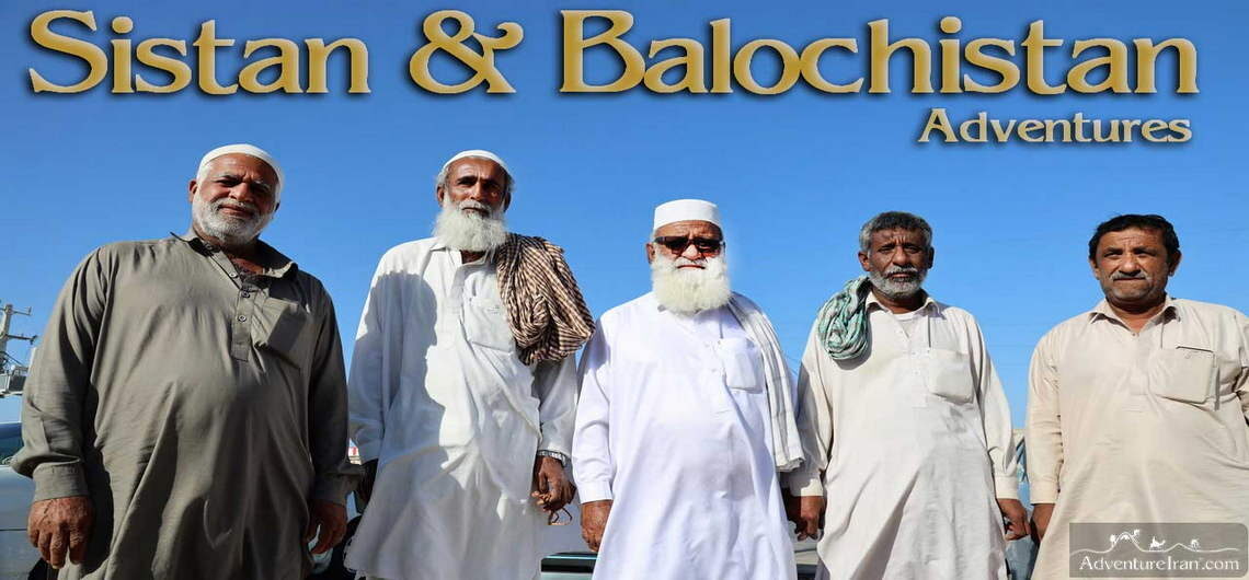
Sistan & Baluchestan Adventures The video is about our adventure journey to Sistan and Baluchestan, which is Iran's most special attraction. This trip started from Tehran with a night train towards Kerman. A jeep took the group to Dasht-e lut desert. After staying one night in the desert they continued the trip towards the north through Kalouts fantasy city in the heart of the desert. After exploring and doing some photography in the desert they drove towards Zabol city (north east of Sistan & Baluchistan) which is one of the main cities of the province and its nearby Afghanistan border (about 50 km). Zabol civilization has a lot of stories in Iranian history and Kuh-e Khuaja in Zabol, standing as one of the most important Iranian historical city-fortresses, pre-Islamic and early Islamic, in the region is on the tentative UNESCO sites of Iran. We also visited Ghale-Now ancient town in the region that still has its special architecture. Afterward the trip continued towards the south to visit Shahr-i Sokhta, meaning ‘Burnt City’, which is one of Iran’s UNESCO sites registered in 2014. They drove to Zahedan, the capital of the province, and spent a couple of nights there to visit different attractions. In the morning they visited the ground Bazaar and the museum which is one of the biggest museums in the region. They had an excursion to the heights of Taftan Mountain which is the most important semi-active volcano of Iran which has an altitude around 4,000 meters above sea level. After visiting Zahedan and countryside attractions they traveled to Kalpuregan ancient village which is nearby from Saravan. Kalpuregan is like a museum of its own and as the capital of pottery in the world has a lot of history in itself. There’s still a lot of artists
Sistan & Baluchestan Adventures The video is about our adventure journey to Sistan and Baluchestan, which is Iran’s most special attraction. This trip started from Tehran with a night train towards Kerman. A jeep took the group to Dasht-e lut desert. After staying one night in the desert they continued the trip towards the north
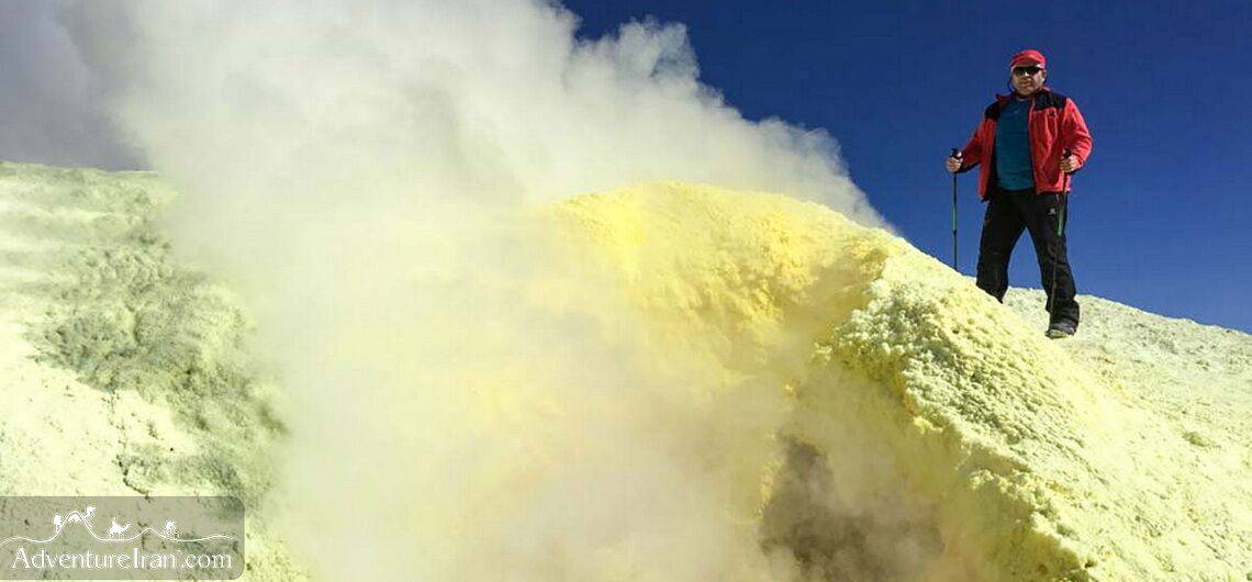
Mount Taftan in Iran Active Volcano Peak Nestled in the southeastern corner of Iran, near the borders of Pakistan and Afghanistan, Mount Taftan stands as one of the country’s most fascinating natural wonders. This dormant stratovolcano, rising to an impressive 4,042 meters (13,261 feet), is not only a geological marvel but also a destination rich in myth, history, and adventure. For travelers seeking a unique and off-the-beaten-path experience, Mount Taftan offers a captivating blend of rugged landscapes, cultural significance, and thrilling outdoor activities. The massive Mount Taftan is situated only 70 km away from the Pakistan border. It is an isolated, active volcanic mountain located in Sistan and Baluchestan province. South of the mountain is Khash, the nearest city. Mt. Taftan has two very famous summits with Chehel Tan peak (Madehkuh) at 3941 m above sea level being the highest one. Iran has numerous mountains over 4000 m, but this, in particular, is one of the more well-known peaks, since it is a solitary mountain in the corner of Iran, with an active volcanic peak. It is attached to Dasht-e lut desert. The Legendary Volcano Mount Taftan, whose name means "burning mountain" in Persian, is part of the Makran volcanic arc. Although dormant, the volcano still emits faint plumes of sulfurous gases, a reminder of its fiery past. Its dramatic peaks, often capped with snow, create a striking contrast against the arid plains of Sistan and Baluchestan Province. The mountain’s unique terrain, shaped by centuries of volcanic activity, features rugged ridges, deep valleys, and colorful mineral deposits, making it a paradise for geology enthusiasts and photographers. Taftan volcanic mountain is a sub-range of Iran’s volcanic arc, with Bazman Mountain in Iran and Sultan Kuh in Pakistan. This volcanic arc has formed over Cretaceous-Eocene sedimentary layers and is derived from
Mount Taftan in Iran Active Volcano Peak Nestled in the southeastern corner of Iran, near the borders of Pakistan and Afghanistan, Mount Taftan stands as one of the country’s most fascinating natural wonders. This dormant stratovolcano, rising to an impressive 4,042 meters (13,261 feet), is not only a geological marvel but also a destination rich