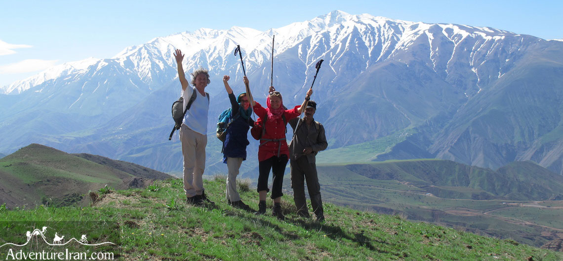
10 Best Off the Beaten Path Hiking Trails in Iran Iran’s geographical location has made it one of the most exceptional countries in the world for hiking. There are two seas in the north and south of the country, as well as the two long mountain ranges of Alborz and Zagros. Moreover, a lot of sub-ranges and mountain chains, high-altitude peaks in each corner of the country, the famous Hyrcanian forests (UNESCO), and two vast deserts of Dasht-e Kavir and Lut (UNESCO) plus numerous springs and lakes have made Iran unique. Iran, with so much to see as well as numerous Off the Beaten hiking trails, is perfect for all types of hikers who wish to experience an unusual and exciting journey. The varieties of terrain and climate have created amazing opportunities for freak (atypical) hikers to hike in different regions all year round. Having excellent information about the Off the Beaten hiking trails in Iran and knowing the right regions in the right month is one of the main steps to have a memorable trekking holiday. Another advantage of Iran is enjoying a varied climate and ecosystem simultaneously in its different regions. To give you a better idea, we will explain a few of Adventure Iran’s tours during spring. While we perform hiking tours in the forests, south of the Caspian Sea, we also have other hiking tours in the central Alborz mountains, north of Tehran. At the same time, we have another hiking tour in the Dasht-e Kavir desert located in central Iran. We have had a lot of experience performing these tours. As there is still snow on the high-altitude mountains in the central parts of the country, you will see a lot of flowers and trees in bloom while people in the south of Iran, in
10 Best Off the Beaten Path Hiking Trails in Iran Iran’s geographical location has made it one of the most exceptional countries in the world for hiking. There are two seas in the north and south of the country, as well as the two long mountain ranges of Alborz and Zagros. Moreover, a lot of
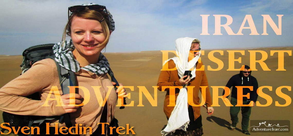
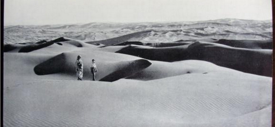
Sven Hedin’s footsteps in Iran Central Desert The video is about a long desert trekking in Dasht-e Kavir desert and is made from different Adventure Iran desert trekking tours from 2011 to 2019. Unfortunately, we haven’t got much footage from our trips and the video was made from what we could get from these memorable trips. But in our Adventure Iran’s photo gallery section you will find a lot of high quality pictures taken from similar tours that we have done in the years. Sven Hedin is a Swedish geographer, topographer, explorer and travel writer who traveled to Iran in 1886 and 1890 and he passed this part of the desert with camels and camel mans so in the hour of his work we named one of our expedition trekking trips after him. The region is Khor and Biabanak which is located in the heart of Iran Central Desert, 400 km east of Isfahan. We designed a trek mostly travelable by camels that passes a number of oases and villages inside of the desert.You can see the remains of the date farms and some agricultural regions in the desert with some sheep and cows on the farms and of course some camels which are the main highlights of the desert. The trail is designed to pass different terrain types like flat desert, soft desert and sand dunes, Salt Lake and mountains. Spring and autumn are the best seasons to take this trek. March and April in spring are perfect as you have more daylight in the desert. In October and November, you have better temperature but the daylight is a couple of hours shorter than spring. You can start your journey from Yazd or Isfahan which are the most popular cities for travelers who visit Iran Classical Routes.
Sven Hedin’s footsteps in Iran Central Desert The video is about a long desert trekking in Dasht-e Kavir desert and is made from different Adventure Iran desert trekking tours from 2011 to 2019. Unfortunately, we haven’t got much footage from our trips and the video was made from what we could get from these memorable
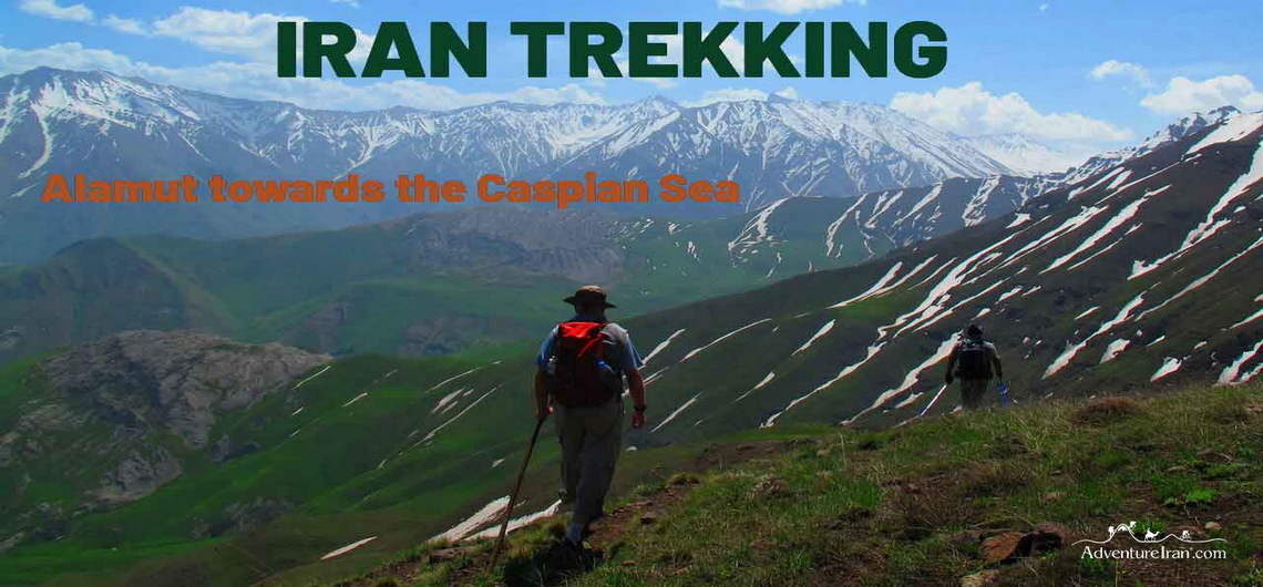
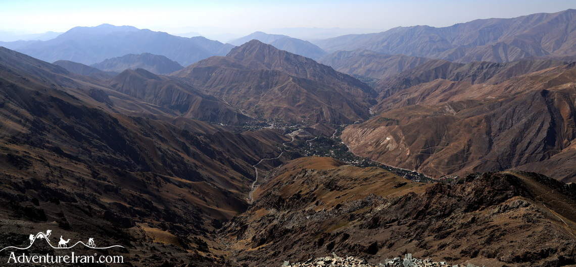
Trekking from Alamut towards the Caspian Sea The video is a slideshow of Adventure Iran’s trekking tours from the Valley of Alamut to the Caspian Sea. As we had not much good footage for this clip we made it with our tour photos which we had from different tours performed in the years with the purpose of showing the beauty of this rout. This trail is one of the most famous trekking routes in Iran which is located in the west Alborz mountains. Lonely Planet also mentioned this route as Iran’s top travel experiences. The starting point of this trail is around the Alamut Castle in the valley of Alamut which is in Qazvin province. And you will finish the trail in Yuj which is in Mazandaran province in the southern part of the Caspian Sea. Geographically, Alamut valley is in the southern part of Alborz mountain and Yuj is on the north side of Alborz. So you should cross the mountain ridge line of Alborz to reach the Caspian Side. The climate of the southern side of Alborz is different from the north side. The season starts from April and finishes in October or sometimes November depending on the weather. In early spring you will face snow in the heights of the mountains and summer is mainly green and in fall the landscape is mostly yellow and brown. In the winter the entire area will be full of snow and the road is blocked from south to north. So the beauty of the landscape and the scenery is changing season by season and that’s why you will see different pictures of nature in the video or in our tour photos on our website (which you can see here). Hope you enjoy the video and if you like it
Trekking from Alamut towards the Caspian Sea The video is a slideshow of Adventure Iran’s trekking tours from the Valley of Alamut to the Caspian Sea. As we had not much good footage for this clip we made it with our tour photos which we had from different tours performed in the years with the
Darbandsar Village in Iran ALBORZ SKI REGION Darbandsar is a village in the heart of the Alborz Mountains of Iran, 60 km away from the capital and northeast of Tehran province. The village is situated on the slope of the southern part of the Central Alborz mountains with various altitudes. The average height is approximately 2600m above sea level. Darbandsar is also the name of the ski resort which was created after Iran’s revolution. Darbandsar village became famous in Iran as the piste is owned by a private company. The company built the length of the ski slope as well as bought a new lift system for the ski resort, which, by the way, is more up-to-date compared to other ski resorts in Iran. Winter time is the busiest time of the year, with Tehranians coming to ski. It is generally even busier at the weekends, (which are Thursday and Friday in Iran). Due to this influx of visitors, the main road (Fasham-Shemshak) is usually packed full of cars at this time. Apart from the ski activity in winter, the region is a perfect destination for other activities such as trekking and mountain biking during other seasons. A lot of high mountains above 3000 m surround this village with plenty of canyons and spring water, flora, and wildlife. Darbandsar is located in the Alborz Markazi protected area which makes this region one of the best places to visit for those who live in the capital and would like to spend their weekend in northern Tehran in the central Alborz Mountains. The highest point of Darbandsar is 2650m, a mountain above the ski resort which locals call Mahmoud Chal peak. There are also a few very high mountains around Darbandsar such as MT Kolonbastak 4150m, Sarakchal 1 (4120m), Sarakchal 2
Darbandsar Village in Iran ALBORZ SKI REGION Darbandsar is a village in the heart of the Alborz Mountains of Iran, 60 km away from the capital and northeast of Tehran province. The village is situated on the slope of the southern part of the Central Alborz mountains with various altitudes. The average height is approximately
Mount Kolon Bastak in Northern Tehran Northern Tehran has countless mountains above 4000 m, which are geographically located in the central Alborz mountains. Mount Kolon Bastak is one of the highest summits in the Central Alborz region in Iran, with an altitude of 4170 m above sea level. The closest village to this summit is Shemshak, 40 km north of Tehran and 60 km from central Tehran. It is the most convenient place to choose for spending the night before your climb. Shemshak village has a 2700 m altitude above sea level. It is famous for being one of the first ski resorts in Iran which opened in 1958. It is the third largest ski area after Dizin and Darbandsar. Mt. Kolon Bastak is an excellent choice for acclimatization before ascending Mt Damavand (5610m) and Alamkuh (4850m), as it is near Tehran city and is not a technical peak. No particular gear or special equipment is needed to ascend the peak in mid-spring, summer, and autumn. You can drive up to 3400 m to the base of the mountain, the starting point of the trek. From the peak, you can continue the trek through the ridge towards the east and then ascend Sarakchal mountain (4210m). There is a renowned mountain trail called Kolon Basatak-Sarak Chal ridge line, another trekking route for experienced hikers who would appreciate a real challenge. The season starts in mid-spring and finishes at the beginning of autumn. In the summertime, the weather is more stable at the peak, making it suitable for all categories of hikers. Kolon Bastak Mountain Ascent (4156 m) is one of the most popular tours that most hikers will benefit from. Mt. Kolon Bastak to Mt. Sarak Chal ridgeline trek is one of Adventure Iran’s special offers for those of you
Mount Kolon Bastak in Northern Tehran Northern Tehran has countless mountains above 4000 m, which are geographically located in the central Alborz mountains. Mount Kolon Bastak is one of the highest summits in the Central Alborz region in Iran, with an altitude of 4170 m above sea level. The closest village to this summit is
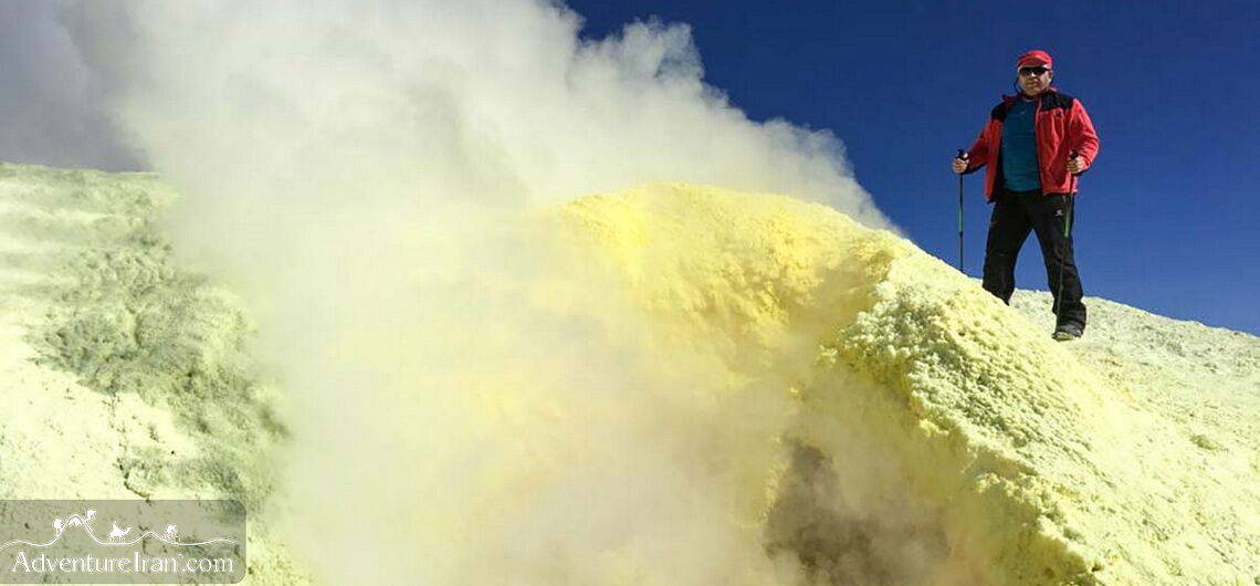
Mount Taftan in Iran Active Volcano Peak Nestled in the southeastern corner of Iran, near the borders of Pakistan and Afghanistan, Mount Taftan stands as one of the country’s most fascinating natural wonders. This dormant stratovolcano, rising to an impressive 4,042 meters (13,261 feet), is not only a geological marvel but also a destination rich in myth, history, and adventure. For travelers seeking a unique and off-the-beaten-path experience, Mount Taftan offers a captivating blend of rugged landscapes, cultural significance, and thrilling outdoor activities. The massive Mount Taftan is situated only 70 km away from the Pakistan border. It is an isolated, active volcanic mountain located in Sistan and Baluchestan province. South of the mountain is Khash, the nearest city. Mt. Taftan has two very famous summits with Chehel Tan peak (Madehkuh) at 3941 m above sea level being the highest one. Iran has numerous mountains over 4000 m, but this, in particular, is one of the more well-known peaks, since it is a solitary mountain in the corner of Iran, with an active volcanic peak. It is attached to Dasht-e lut desert. The Legendary Volcano Mount Taftan, whose name means "burning mountain" in Persian, is part of the Makran volcanic arc. Although dormant, the volcano still emits faint plumes of sulfurous gases, a reminder of its fiery past. Its dramatic peaks, often capped with snow, create a striking contrast against the arid plains of Sistan and Baluchestan Province. The mountain’s unique terrain, shaped by centuries of volcanic activity, features rugged ridges, deep valleys, and colorful mineral deposits, making it a paradise for geology enthusiasts and photographers. Taftan volcanic mountain is a sub-range of Iran’s volcanic arc, with Bazman Mountain in Iran and Sultan Kuh in Pakistan. This volcanic arc has formed over Cretaceous-Eocene sedimentary layers and is derived from
Mount Taftan in Iran Active Volcano Peak Nestled in the southeastern corner of Iran, near the borders of Pakistan and Afghanistan, Mount Taftan stands as one of the country’s most fascinating natural wonders. This dormant stratovolcano, rising to an impressive 4,042 meters (13,261 feet), is not only a geological marvel but also a destination rich
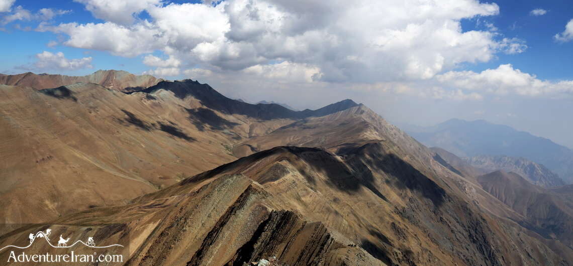
Mount Sarak Chal in Iran Mount Sarak Chal (or Sarakchal) is one of the highest summits in the central Alborz Mountains in Iran, at 4210m above sea level. There are three Sarak Chal peaks which are located on the famous Kolon Bastak-Sarak Chal mountain ridge line. All three mountains are above 4000 m. The closest village to this mountain is Shemshak, the last one on the famous mountainous road of Tehran-Fasham. It is 60 km away from downtown Tehran. As a matter of interest, one of the most notable ski resorts in Iran for professional skiers is in Shemshak village. The altitude of the village is about 2700 m above sea level, which is the starting point of the trek to Sarak Chal peak. There is a shelter at 3492 m on the way to the peak, which is convenient as it is also the ideal location for acclimatization. There is a 15 km famous ridgeline above Shemshak village from west to east, which starts from Mount Koloon Bastak (4170m) in the west and ends at Mount Sarak Chal 3 (4210m) in the east. Between these two mountains, there are the two peaks of Sarak Chal 1 (4080m) and Sarak Chal 2 (4100m), making this ridgeline very challenging. From the peak, you have an excellent view of the immense Central Alborz mountains. In clear weather, you can see most of them, such as the Abak (3520m), Kholeno (4387m), Azadkuh (4350m), and Borj (4326m) mountains as well as the mighty Damavand (5610m), the roof of Iran. The season runs from mid-spring till the beginning of autumn. Summertime is the most popular period for ascending the mountain, as the weather is more stable for trekking. Mount Sarak Chal Ascend is the shortest hiking tour that we offer for this mountain. Hike
Mount Sarak Chal in Iran Mount Sarak Chal (or Sarakchal) is one of the highest summits in the central Alborz Mountains in Iran, at 4210m above sea level. There are three Sarak Chal peaks which are located on the famous Kolon Bastak-Sarak Chal mountain ridge line. All three mountains are above 4000 m. The closest
Mount Sabalan Iran’s Sacred Volcanic Summit Mount Sabalan, located in Ardabil Province in northwestern Iran, is the country’s third highest peak, and third tallest volcanoes in Asia standing at 4,811 meters (15,784 feet). This majestic mountain is an extinct stratovolcano, known not only for its challenging trekking routes but also for its breathtaking landscapes and spiritual aura. At its summit, trekkers are rewarded with a spectacular crater lake, frozen for most of the year, which adds a surreal beauty to the high-altitude experience. The mountain’s volcanic nature has shaped its dramatic terrain—featuring lava flows, rocky outcrops, and hot springs scattered throughout the region. These geothermal features, along with the clear skies and alpine flora, make Sabalan a unique destination for nature lovers, adventure seekers, and mountaineers. The slopes are dotted with wildflowers in spring and summer, turning the area into a natural paradise for trekking, photography, and wildlife observation. Trekking Mount Sabalan does not require technical climbing skills in the summer months, but due to its elevation, proper acclimatization is strongly recommended. Adventure Iran offers short trekking tours to Sabalan, suitable for those who want to experience high-altitude trekking in Iran without the need for heavy mountaineering equipment. The normal route to the summit starts from the Shabil hot spring area, where trekkers can enjoy a relaxing soak before or after their climb. Beyond its natural beauty, Sabalan is considered a sacred mountain by locals. Legends connect it with ancient Persian mythology and spirituality. Many believe that the prophet Zoroaster meditated on its slopes, and the mountain has long been a symbol of endurance and purity for the people of the region. So far, not too many foreign climbers choose this pinnacle as it is in the northwest corner of the country, far from the capital. However, it certainly
Mount Sabalan Iran’s Sacred Volcanic Summit Mount Sabalan, located in Ardabil Province in northwestern Iran, is the country’s third highest peak, and third tallest volcanoes in Asia standing at 4,811 meters (15,784 feet). This majestic mountain is an extinct stratovolcano, known not only for its challenging trekking routes but also for its breathtaking landscapes
Mount Alam kuh in Iran Alam Kuh, is the name of a huge mountain in northern Iran, in Mazandaran province, located in the Takht-e Soleyman massif mountain chain. Takht-e Soliman is also a part of the west Alborz Mountain range. Alam Kuh’s altitude is 4,850 m above sea level and is the second highest mountain in Iran after Damavand Mountain (5,610 m). Mount Alam Kuh is known as the Alps of Iran, which is the main center for professional Iranian climbers and hikers. The north face of Mt Alam Kuh is a steep, enormous vertical wall. This feature has made it famous for climbers around the world looking for something different. The height of this granite rock rises to about 480 m to reach the summit. One of the main highlights is that the base of the wall starts from 4,400 m above sea level. Climbers have found this formation extremely inspiring and challenging. Since 1936, there have been several routes to choose from, all created by famous international and local climbers. They are still ongoing. Mount Alam Kuh has at least two desirable hiking routes to reach its peak from various directions. One of the most beautiful is a week-long trail starting from the southern side of Alborz from Alamut valley to MT Alam Kuh. This is the link for the tour: Alamut Long Trek. Apart from this, there is another trail to ascend the peak starting from a city near the Caspian Sea called Kelardasht. Most local climbers choose this route for ascending the summit during the summertime. Locals call this route Hesarchal which is on the south face of Alam Kuh as it is the easiest and shortest route compared to the other trails. Below is the link for that trek, (an excellent choice for
Mount Alam kuh in Iran Alam Kuh, is the name of a huge mountain in northern Iran, in Mazandaran province, located in the Takht-e Soleyman massif mountain chain. Takht-e Soliman is also a part of the west Alborz Mountain range. Alam Kuh’s altitude is 4,850 m above sea level and is the second highest mountain
Alfons Gabriel and Iran Alfons Gabriel (1894 – 1976) was an Austrian geographer and travel writer who made several trips to Iran’s deserts. Gabriel wrote five books about his trips and findings in Iran. His book, Durch Persians Wüsten (1935, meaning Through Persia’s Deserts), has been translated into Persian. On his second trip to Iran in 1933, he crossed Dasht-e Kavir (the Central Desert) where he discovered the flagstone road dating back to the time of Shah Abbas, the Safavid King. He made his third trip to Iran in 1937 crossing the southern part of Dasht-e Lut. Not many pictures of Gabriel survived but it is said that one of them, taken with his wife in front of their tent, is of Aroosan village in the Central Desert. Gabriel has written many beautiful things about this village in his books. Alfons Gabriel's journeys—spanning the 1920s–1930s—produced groundbreaking maps, ethnographic studies, and photographic records of remote regions few Westerners had ever seen. Key Expeditions & Discoveries Crossing the Lut Desert (1933) Gabriel was among the first Europeans to document the Dasht-e Lut’s hyper-arid core, confirming its status as one of Earth’s hottest places. His temperature readings (published in The Lut: Scientific Results of a Desert Expedition) remain cited in climate studies. Mapping Baluchistan’s “Forbidden Zones” Venturing into Sistan and Baluchestan, he recorded nomadic tribes like the Baluch and Brahui, their customs, and hidden oases—later detailed in his book Through Persia’s Deserts. Medical Ethnography As a doctor, Gabriel studied local diseases and traditional healing practices, even noting the use of camel urine as a disinfectant by desert tribes. Controversies & Legacy Colonial Tensions: His work, funded by European institutions, sometimes clashed with Reza Shah’s modernization efforts. Forgotten Archives: Thousands of his photos (held in Vienna’s museums) reveal lost Iran—from Qajar-era bazaars to vanishing
Alfons Gabriel and Iran Alfons Gabriel (1894 – 1976) was an Austrian geographer and travel writer who made several trips to Iran’s deserts. Gabriel wrote five books about his trips and findings in Iran. His book, Durch Persians Wüsten (1935, meaning Through Persia’s Deserts), has been translated into Persian. On his second trip to Iran