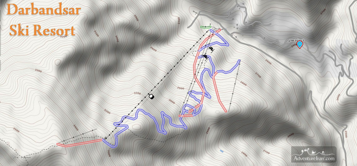
Darbandsar Ski Resort in Iran ALBORZ SKI REGION Darbandsar ski resort in Iran is one of the main ski resorts in the country, located in Darbandsar village, northeast of the capital. From Tehran, it is only 65km away and takes one and half hours to reach it. The history of the piste goes back to around the time of the Iran Islamic revolution. Before the revolution, many local skiers traveled to Europe for the ski championships. With the help and support of a few ski enthusiasts from various countries, decisions were made to create a new ski resort in the Alborz Ski Region. They bought a brand-new lift from the Poma company in France in 1978. This lift was kept in Iran’s customs control for a period due to the timing of the revolution. This project was suspended until things had settled down so it took longer than originally planned. After a few years, actually, at the beginning of 1982, the Darbandsar piste was born. Subsequently, the locals bought more ski lift equipment to improve the piste and make it more advanced and keep pace with other pistes in Iran. The altitude is 2600m to 3600m. This piste, as mentioned, is located in the Alborz ski region in the Central Alborz Mountains. Darbandsar ski resort was originally a small piste in Iran. Fortunately, it now belongs to a private company that developed the region and purchased new ski lift equipment. It is fast increasing in size, overtaking Shemshak and Tochal pistes. Nowadays Darbandsar is an important and well-known ski hub for Iranian skiers. It is also becoming more popular with locals. Lift Systems: 1st station: 2600m Last station: 3600m The ski resort has two ski lifts, three chair lifts (two 4-seater ski lifts, one two-seater chair
Darbandsar Ski Resort in Iran ALBORZ SKI REGION Darbandsar ski resort in Iran is one of the main ski resorts in the country, located in Darbandsar village, northeast of the capital. From Tehran, it is only 65km away and takes one and half hours to reach it. The history of the piste goes
Iran plans to open their borders again for travellers. Visa restrictions in Iran have been lifted The world is opening up and Iran will start issuing tourist visas again from next month. Iran’s Travel Visa will be issued after 18 months The new government of Iran plans to resume issuing Travel Visas after 18 months of suspension amid strict government measures to prevent the spread of coronavirus. Iran’s new Minister of Tourism announced on 28 September 2021, World Tourism Day, that the restrictions for travelling to Iran will be lifted very soon. Visas will be issued for travellers starting next month. Since March 2020, due to the Covid-19 pandemic, all of Iran’s borders were closed to the world. This resulted in the Ministry of Foreign Affairs stopping the issue of visas. From that time, all travellers holding visas that had previously been issued, couldn’t enter the country. Their trips have had to be postponed until the borders are reopened. On 18 June 2021, presidential elections were held in Iran. Iran’s latest president, “Ebrahim Raisi“, became the incumbent on 5 August 2021. The government and Tourism Board changed its Ministers accordingly. Ezzatollah Zarghami was elected as the new Minister of Cultural Heritage, Tourism and Handicraft. He has announced that Iran’s visa restrictions will be lifted in October 2021. The new government’s approval of the issuance of Iranian travel visas has been notified to all relevant organizations and tour operators. Instructions on travelling to Iran and the necessary conditions regarding the observance of health protocols for travelling here will be subsequently announced on the sites blogs and emails to customers. For more information of Iran Travel Visa please please check following link: IRAN Tourist Visa General Info
Iran plans to open their borders again for travellers. Visa restrictions in Iran have been lifted The world is opening up and Iran will start issuing tourist visas again from next month. Iran’s Travel Visa will be issued after 18 months The new government of Iran plans to resume issuing Travel Visas after 18
Dizin Ski Resort ALBORZ SKI REGION Dizin is the biggest Ski Resort in Iran, located in Alborz province, northeast of Tehran province, which is on the southern slopes of the Central Alborz Mountains. Dizin ski resort was built around 1960 during the reign of Pahlavi (Mohammad Reza Shah) before Iran’s Islamic revolution. The piste is situated in a staggeringly beautiful geographical position, surrounded by a lot of high mountain peaks around +4000 m, which makes for a very cold winter with amazing visibility of the mountains in the Alborz range. You will have a stunning view of Iran’s highest mountain, Damavand (5610m), from the top of the piste on Sichal peak. From the last station of Dizin, you have to ascend a little bit. It takes 10-15 minutes to reach the peak (Sichal), the highest point in the region. From there, you will have a breathtaking 360-degree panoramic view of the numerous mountains in the heart of Alborz. From the peak, you can see Kolonbastak (4150m), the ridgeline of the Sarakckal mountains, a 15km mountain chain above 4000m with 3 peaks. In the south, you will see Tochal mountain (3960m) which is north of the capital, Tehran. Dizin is, without a doubt, the finest place for skiing in Iran. For those who are looking for a more challenging activity, there are a lot of regions around Dizin that are terrific for Off Piste skiing. You will need a local guide or experienced ski instructor for off-piste skiing in Dizin. There are a few mountains around Dizin that are excellent for Ski-Touring at the end of winter and the beginning of spring. Mount Kolonbastak and Mount Azadkuh are two of them, which are fairly close, and ideal for ski touring. Besides ski activities, the attractive Dizin region is
Dizin Ski Resort ALBORZ SKI REGION Dizin is the biggest Ski Resort in Iran, located in Alborz province, northeast of Tehran province, which is on the southern slopes of the Central Alborz Mountains. Dizin ski resort was built around 1960 during the reign of Pahlavi (Mohammad Reza Shah) before Iran’s Islamic revolution. The
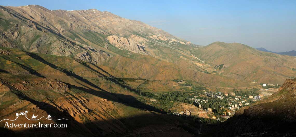
Darbandsar Village in Iran ALBORZ SKI REGION Darbandsar is a village in the heart of the Alborz Mountains of Iran, 60 km away from the capital and northeast of Tehran province. The village is situated on the slope of the southern part of the Central Alborz mountains with various altitudes. The average height is approximately 2600m above sea level. Darbandsar is also the name of the ski resort which was created after Iran’s revolution. Darbandsar village became famous in Iran as the piste is owned by a private company. The company built the length of the ski slope as well as bought a new lift system for the ski resort, which, by the way, is more up-to-date compared to other ski resorts in Iran. Winter time is the busiest time of the year, with Tehranians coming to ski. It is generally even busier at the weekends, (which are Thursday and Friday in Iran). Due to this influx of visitors, the main road (Fasham-Shemshak) is usually packed full of cars at this time. Apart from the ski activity in winter, the region is a perfect destination for other activities such as trekking and mountain biking during other seasons. A lot of high mountains above 3000 m surround this village with plenty of canyons and spring water, flora, and wildlife. Darbandsar is located in the Alborz Markazi protected area which makes this region one of the best places to visit for those who live in the capital and would like to spend their weekend in northern Tehran in the central Alborz Mountains. The highest point of Darbandsar is 2650m, a mountain above the ski resort which locals call Mahmoud Chal peak. There are also a few very high mountains around Darbandsar such as MT Kolonbastak 4150m, Sarakchal 1 (4120m), Sarakchal 2
Darbandsar Village in Iran ALBORZ SKI REGION Darbandsar is a village in the heart of the Alborz Mountains of Iran, 60 km away from the capital and northeast of Tehran province. The village is situated on the slope of the southern part of the Central Alborz mountains with various altitudes. The average height is approximately
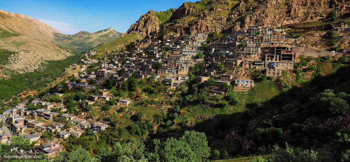
Iranian UNESCO Site of Hawraman (Uramanat) Hawraman (or Uramanat) is the name of a historical valley located in the mountains shared between the two provinces of Kurdistan and Kermanshah in the west of Iran. Uraman is the Kurdish word for Hawraman which is pronounced Huraaman. Generally, in different parts of Iran, it is called Uraman, Uraaman, or Avroman. It means the land of Ahura Mazda (the supreme god in ancient Iranian religion) in ancient Persian language. It is also the name of the mountainous region of Hawraman valley. In June 2021, The Cultural Landscape of Hawraman/Uramanat was inscribed on the UNESCO World Heritage List as the 26th tangible cultural heritage of Iran at the 44th session of the UNESCO World Heritage Committee. This valley, unknown for many years, is one of the main natural/historical attractions of the west of Iran. Along with the long history of the region and Kurdish people, the valley has many villages which have unique stair-like architecture. The villages are special in the way the rural areas house many dense and step-like rows of accommodation in such a way that the roof of each house forms the yard of the upper one, making it an exceptional sight to see. The rich culture of the Hawramani people which is famous for their hospitality is one of the other attractions of Uramanat and makes this destination different from other regions. Since 3000 BCE Kurdish tribes have inhabited the region and lived on the economy based on agro-pastoral activities in this valley. Kurdish people are famous for being the tough guys and they are used to live and survive in the mountains for many years. Hawraman or Uramanat is in the heart of the Zagros Mountains range, one of the two main mountain ranges of Iran, where
Iranian UNESCO Site of Hawraman (Uramanat) Hawraman (or Uramanat) is the name of a historical valley located in the mountains shared between the two provinces of Kurdistan and Kermanshah in the west of Iran. Uraman is the Kurdish word for Hawraman which is pronounced Huraaman. Generally, in different parts of Iran, it is called
Sistan and Baluchistan in Iran Sistan and Baluchistan province (also spelled Sistan and Baluchestan / Balochistan) is in the southeast of Iran on the border with Afghanistan and Pakistan. To the south lies the Indian Ocean and the Gulf of Oman. This province is about the size of Switzerland, the Netherlands, Belgium, Denmark, and Slovenia combined. As a result of its huge dimensions, there is a fair amount of driving from the north to the south. It has 1,100 km of land along the border with Pakistan and Afghanistan together with a coastal stretch of 300 km along the Indian Ocean’s Gulf of Oman. The inhabitants consist of two tribes, one is the Baluchi tribe, who are Sunni Muslims, and the other the Sistani tribe, who are Shi’a Muslims. Both speak Persian. Balochistan offers adventurous travelers a unique opportunity to explore a region rich in ethnic culture, ancient traditions, and surreal landscapes. This vast province is part of Sistan and Baluchestan, one of Iran’s largest and most ethnically diverse regions. Though historically overlooked due to its remoteness, it’s now emerging as a fascinating destination for those seeking something truly different. The province is really amazing with huge contrasts between the deserts, snow-capped mountains, peculiar rock formations, an active 4,000 m volcano, Martian scenery, cliff-enclosed fishing villages along the coast, plus tropical rivers with the rare Mugger crocodile. This is a lesser-known destination in Iran but, at the same time, one of the most beautiful areas of our country. Top Places to Visit in Iranian Balochistan 1. Chabahar The gateway to Balochistan, Chabahar is a strategic port city on the Gulf of Oman, and one of the few coastal towns in Iran with a tropical climate. Highlights: 🌊 Martian Mountains (Miniature Mountains): Otherworldly rock formations with dramatic ridges that
Sistan and Baluchistan in Iran Sistan and Baluchistan province (also spelled Sistan and Baluchestan / Balochistan) is in the southeast of Iran on the border with Afghanistan and Pakistan. To the south lies the Indian Ocean and the Gulf of Oman. This province is about the size of Switzerland, the Netherlands, Belgium, Denmark, and Slovenia
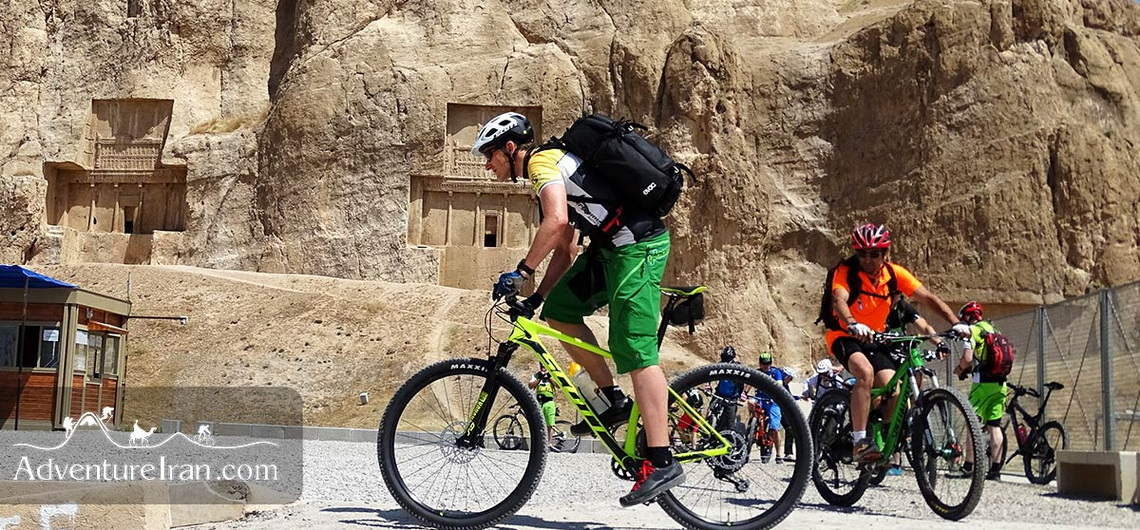
Cycling in Iran Iran consists of distinctive lands and climate. The terrain includes mountains, deserts, forests and seas which give both beginner cyclists and adventurous mountain bikers so many choices. From the hot temperature of the Persian Gulf coast, (at sea level), in the south, to the Mt Damavand at 5,610 m, the highest mountain in the Middle East, there are a wide range of options for cycling. You can choose to cycle: on a road on one of the islands in the southern part of the Persian Gulf or have an adventure expedition by cycling across one of our deserts or if you are an experienced cyclist, the tough single-track mountain biking on the heights of the Alborz or Zagros mountains may be for you. For advanced bikers, we can offer to ascend Mt Damavand with a Mountain Bike. We offer various destinations for your adventure journey to Iran taking into account the challenging terrain, your riding experience, your fitness and endurance level and time of travel. In Adventure Iran, our mountain biking trips start from one-day easy cycling tours in the north of Tehran to one-month tours. The Iranian Coast to Coast by Bicycle tour is one of the best examples of Adventure Iran’s long Mountain Biking tour. There are plenty of options for cycling with this particular one starting off from the Persian Gulf and finishing at the Caspian Sea. You can see that our enchanting country has a lot of potential for carrying out exceptional types of cycling tours, with something for everyone to fit their experience and wishes. If you are unable to bring your own bicycle, you can hire one from Adventure Iran. We provide good quality bicycles from XS to XL size. We have both cross country and enduro mountain
Cycling in Iran Iran consists of distinctive lands and climate. The terrain includes mountains, deserts, forests and seas which give both beginner cyclists and adventurous mountain bikers so many choices. From the hot temperature of the Persian Gulf coast, (at sea level), in the south, to the Mt Damavand at 5,610 m, the highest