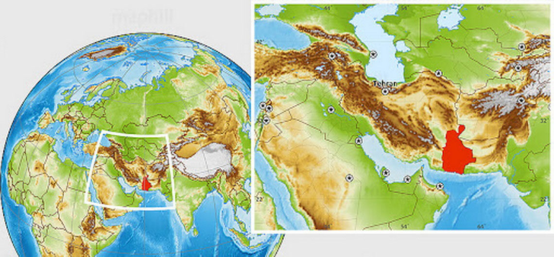
Sistan and Baluchistan in Iran Sistan and Baluchistan province (also spelled Sistan and Baluchestan / Balochistan) is in the southeast of Iran on the border with Afghanistan and Pakistan. To the south lies the Indian Ocean and the Gulf of Oman. This province is about the size of Switzerland, the Netherlands, Belgium, Denmark, and Slovenia combined. As a result of its huge dimensions, there is a fair amount of driving from the north to the south. It has 1,100 km of land along the border with Pakistan and Afghanistan together with a coastal stretch of 300 km along the Indian Ocean’s Gulf of Oman. The inhabitants consist of two tribes, one is the Baluchi tribe, who are Sunni Muslims, and the other the Sistani tribe, who are Shi’a Muslims. Both speak Persian. Balochistan offers adventurous travelers a unique opportunity to explore a region rich in ethnic culture, ancient traditions, and surreal landscapes. This vast province is part of Sistan and Baluchestan, one of Iran’s largest and most ethnically diverse regions. Though historically overlooked due to its remoteness, it’s now emerging as a fascinating destination for those seeking something truly different. The province is really amazing with huge contrasts between the deserts, snow-capped mountains, peculiar rock formations, an active 4,000 m volcano, Martian scenery, cliff-enclosed fishing villages along the coast, plus tropical rivers with the rare Mugger crocodile. This is a lesser-known destination in Iran but, at the same time, one of the most beautiful areas of our country. Top Places to Visit in Iranian Balochistan 1. Chabahar The gateway to Balochistan, Chabahar is a strategic port city on the Gulf of Oman, and one of the few coastal towns in Iran with a tropical climate. Highlights: 🌊 Martian Mountains (Miniature Mountains): Otherworldly rock formations with dramatic ridges that
Sistan and Baluchistan in Iran Sistan and Baluchistan province (also spelled Sistan and Baluchestan / Balochistan) is in the southeast of Iran on the border with Afghanistan and Pakistan. To the south lies the Indian Ocean and the Gulf of Oman. This province is about the size of Switzerland, the Netherlands, Belgium, Denmark, and Slovenia
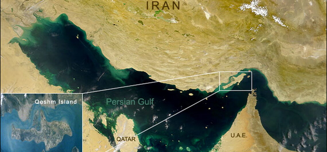
Qeshm Island in Iran Qeshm Island, in Hormozgan province, Iran, is the largest island in the waters of the Persian Gulf. We have always heard a lot about the unique beauties and features of this island. The countless attractions have made Qeshm one of the most important tourist destinations in Iran. It is located in the Strait of Hormuz and has long belonged to Iran. Its pristine and beautiful nature, together with its history dating back to the Sassanid era, has made this southern island a popular tourist destination for many Iranians and foreign tourists. Qeshm Island has an area of 460 square miles (1,200 square km). The beaches are generally rocky, except for the northwest coast, with its sandy bays and muddy plains. Irregular hills cover most of Qeshm. Several of them are more than 900 feet (270 meters) high, and one of them, Kish Kuh, reaches 1,331 feet (406 meters). Salt is extracted on the southeastern shores and there are springs of naphtha. The island is largely barren, but cereals, vegetables, melons, and dates are grown there. Fishing and weaving are common in this region. Shipbuilding is also one of the oldest indigenous industries of the people of Qeshm. On the 5th of May 2017, Qeshm Island was designated as a UNESCO Global Geopark. This Geopark has the shape of a dolphin. The world's longest salt cave is also situated on the island. It is 6,600 meters long. In addition to the formation of salt and complex, other sedimentary formations are located in various anticline structures on it. The island has rich wildlife; various birds, reptiles, dolphins, and turtles can be seen in this area. In Qeshm Island, zoo geographical areas of Palearctic and Oriental, and phytogeographical areas of Afro-tropical, Oriental and Eurasian face each
Qeshm Island in Iran Qeshm Island, in Hormozgan province, Iran, is the largest island in the waters of the Persian Gulf. We have always heard a lot about the unique beauties and features of this island. The countless attractions have made Qeshm one of the most important tourist destinations in Iran. It is located in
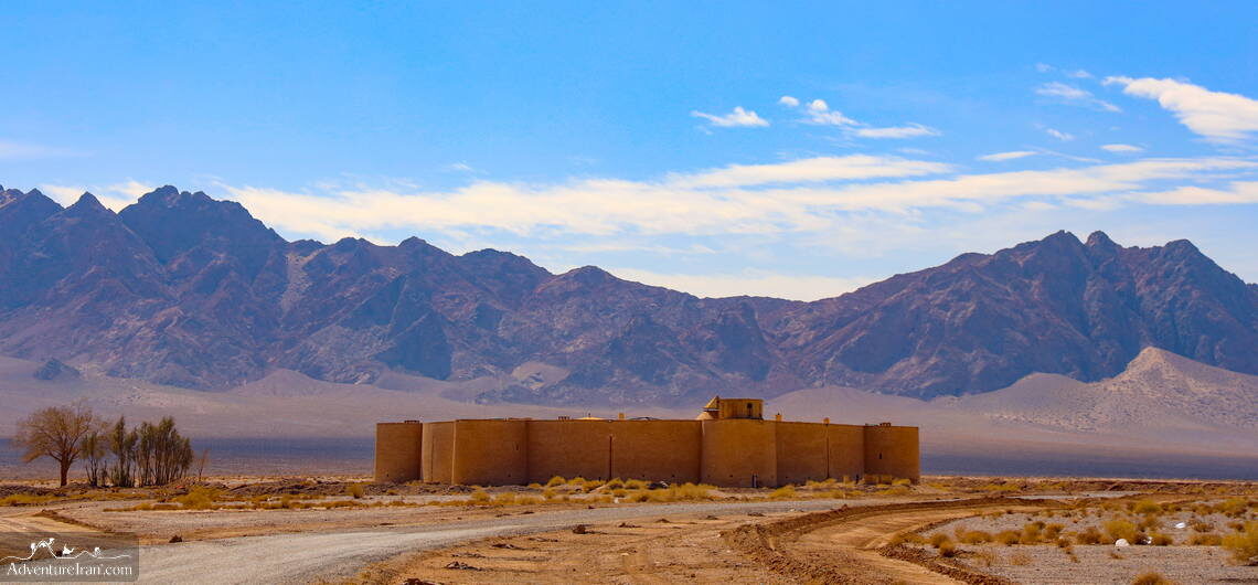
Iran Caravanserais Iran Caravanserais (UNESCO) were built during the Safavid dynasty on the Silk Road route of Persia. These were essential to service the needs of the influx of traders and travelers passing through. At that time, the country was massive and called Persia. During that dynasty, Iran had a main role in the Silk Road route from China to East Europe. The foremost purpose of a caravanserai on the ancient Silk Road was for accommodation and as a gathering place for caravans and travelers. A “Caravanserai” is basically a roadside dwelling similar to an “inn”, built to shelter men, camels, animals such as goats, goods, and other possessions of the caravans. This is how society during that period understood the usage of the caravanserai. Caravanserai was particularly valuable as a link to other trade routes along the former Silk Road. In addition, there was also a large network of caravanserais built along the whole trade path in the Middle East and Central Asia. Throughout the history of the various Muslim kingdoms in India, Asia, North Africa, and South-Eastern Europe, this network, most notably along the Silk Road, was vital to support the flow of information, commerce, pilgrims, and travelers from the 9th until the 19th centuries. The word caravanserai is a Westernized form of the Persian word, which merges “caravan” with “sarayi” or “serai”. This means a palace, a dwelling, or enclosed courts. It is also known as caravansary. “Caravan” has a similar meaning in English, which refers to a troop of soldiers, merchants, pilgrims, or other travelers participating in a long-distance journey. Although caravanserais were constructed in a vast geographical region covering Central Asia, Asia, India, Middle East, North Africa, and South-Eastern Europe, a substantial number of them were also located in the Middle East, Central
Iran Caravanserais Iran Caravanserais (UNESCO) were built during the Safavid dynasty on the Silk Road route of Persia. These were essential to service the needs of the influx of traders and travelers passing through. At that time, the country was massive and called Persia. During that dynasty, Iran had a main role in the
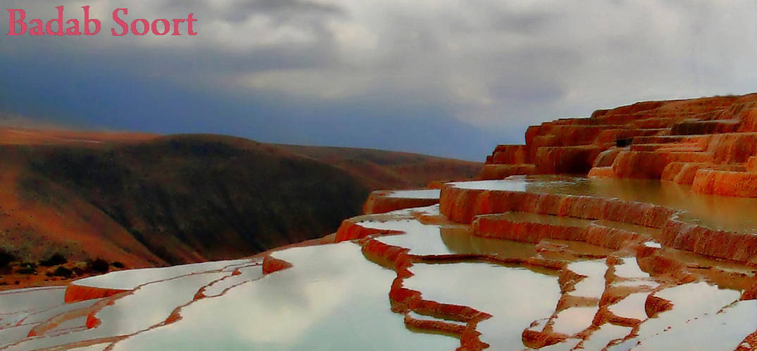
Badab-e Surt Natural Springs in Iran Consider a stepped spring, surrounded by wild trees and barberry bushes, where the color and fragrance of the water on each step is different from the previous one. Looking down from above the spring, you will see forests of coniferous trees. Isn't that fascinating? If you haven't guessed so far that we are talking about Badab-e Surt, you must read this article to the end to find out why this impressive and strange spring has been registered on the Iran National Heritage List. Mazandaran province in Iran is located between the magnificent Caspian Sea and the Alborz Mountain range. Due to its unique beauty and pleasant weather, this province hosts millions of Iranian and foreign tourists every year. Badab-e Surt Spring, Mazandaran province, is south of Sari city, and west of Orost village. It is considered to be one of the most breathtaking and unbelievable spectacles in the area. It is situated at a height of 1,841 meters above sea level. It is commonly assumed that the spring was formed during the Paleocene Era, simultaneously with the most recent folds in the Alborz Mountain range. Badab is the Persian combination of two words; Bad means ‘gas’ and ab means ‘water’. So, Badab means ‘gassed water’ which implies that the spring water is actually carbonated mineral water. Surt is a former name of the nearby Orost village. The Persian word means intensity. Badab-e Surt was created a few thousand years ago by a variety of stepped travertine terrace formations. Over the years, the running water from the two very warm mineral springs cooled and placed carbonate minerals on the mountainside. The Badab-e Surt Spring in Iran is made up of two detached springs with thoroughly contrasting colored and scented water. The first
Badab-e Surt Natural Springs in Iran Consider a stepped spring, surrounded by wild trees and barberry bushes, where the color and fragrance of the water on each step is different from the previous one. Looking down from above the spring, you will see forests of coniferous trees. Isn’t that fascinating? If you haven’t guessed
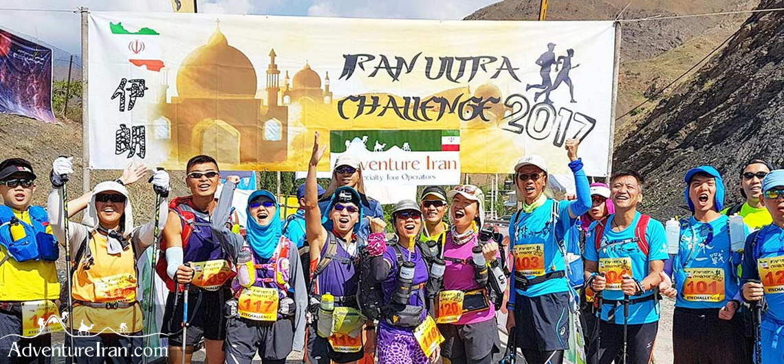
Ultra Trail Mount Damavand in Iran UTMD (Ultra Trail Mount Damavand) is an Ultra Trail Marathon in Iran conducted in the Lar National Park and on the west side of volcanic Mt Damavand (5,610 meters, the highest mountain in the Middle East). Adventure Iran started organizing this approximately 100 km race in 2017. It is an annual summer competition, with many runners from all over the world participating in this contest, simultaneously enjoying the race itself, and the experience of being in the foothills of Damavand Mountain. The race takes place in the beautiful Lar National Park, run by the Mountaineering Federation of Iran. This is a race for everyone: UTMD 100 km, PLP 61 km, and PGP 22 km. Both the start point and finish point are at the Polour Mountain Federation hut. The race route covers some of the most stunning scenery of Lar National Park and Mt. Damavand, including remote and unspoiled grasslands, nature trails, Lar reservoir, and exquisite steep hills. This is a unique, unparalleled, and challenging running competition for trail running enthusiasts. It is also a great opportunity to participate in an unforgettable event. The race has a website that is organized by Adventure Iran and other co-organizers since 2018. https://www.adventureiran.com/lar-national-park/
Ultra Trail Mount Damavand in Iran UTMD (Ultra Trail Mount Damavand) is an Ultra Trail Marathon in Iran conducted in the Lar National Park and on the west side of volcanic Mt Damavand (5,610 meters, the highest mountain in the Middle East). Adventure Iran started organizing this approximately 100 km race in 2017. It
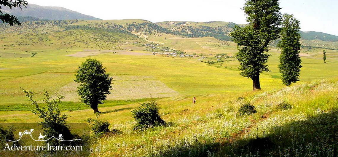
Jahan Nama Protected Area A small village of Jahan Nama by the Caspian Sea gave the name to the vast Jahan Nama Protected Area in the Golestan Province in Iran. With rich wildlife, including wild sheep and goats, wolfs, panthers, bears, weasels, owls, eagles, cuckoos, woodpeckers, and porcupines, Jahan Nama is also famous for its variety of plants and trees, including barberry, Sorkhdar, Kolah-e Mir Hassan, Bolandmaza Namdar, Borage Cowslip, Ras, Darmaneh, and many others. During the studies performed here between 1999 and 2008, 1,350 species were identified, including 607 vascular plant species from 85 families. There are also many seasonal birds in the park and a lot of rivers and springs. The highlands of Jahannama are the most suitable habitats for various hunting birds such as the golden eagles, as well as large partridges. Jahan Nama Park, with an area of about 38 ha, is the largest protected area in Mazandaran province, after Golestan National Park. It is part of the Hyrcanian forests (UNESCO), which are among the oldest forests in the world. The beauties and attractions of the Jahan Nama region are not only limited to its rich flora and fauna and intact nature. The 35-meter Radkan Tower, also known as Mil Radkan, is one of the main historical attractions in this area. It is a cylindrical brick tower dating back to the 13th century. Ziarat Waterfall is another natural attraction in the northeast of the region, located about 5km from Ziarat Village. The village is one of the most beautiful tourist villages in Iran. The pristine nature of the park makes it an ideal hiking destination and we, at Adventure Iran, have created a long hiking trail, which starts south of the Great Gorgan Wall and stretches all the way to the Jahan Nama National Park.
Jahan Nama Protected Area A small village of Jahan Nama by the Caspian Sea gave the name to the vast Jahan Nama Protected Area in the Golestan Province in Iran. With rich wildlife, including wild sheep and goats, wolfs, panthers, bears, weasels, owls, eagles, cuckoos, woodpeckers, and porcupines, Jahan Nama is also famous for its variety